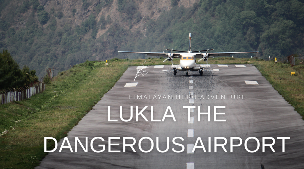
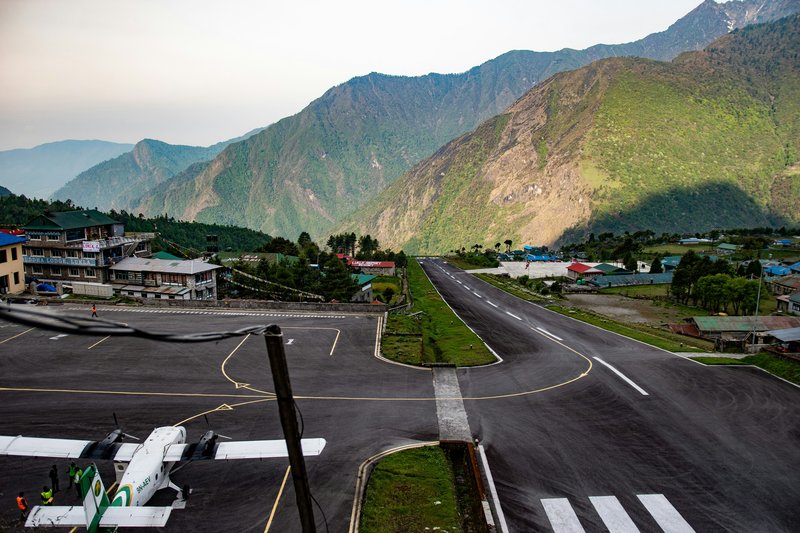
Perched on a narrow mountain ledge at 2,845 meters (9,334 feet), Lukla Airport holds the infamous title of the most dangerous airport in Nepal — and arguably the world's most dangerous airport. Officially known as Tenzing-Hillary Airport since its February 2008 renaming, this small airstrip serves as the primary gateway to Mount Everest, welcoming over 30,000 trekkers annually who are willing to brave what many consider the deadliest airport approach in aviation.
The dangerous airport in Nepal has earned its fearsome reputation through a combination of extreme factors: an impossibly short runway measuring just 527 meters, a 12% gradient slope, unpredictable Himalayan weather, and a cliff drop at the end of the strip. Yet despite these dangers, flights to Lukla continue daily during trekking seasons, carrying adventurers toward Everest Base Camp.
This comprehensive guide explores why Lukla airport dangerous conditions persist, examines the Lukla airport safety record, and provides essential information for travelers planning to experience this extraordinary — and terrifying — mountain airport firsthand.
What Is Lukla Airport and Where Is It Located?
Tenzing-Hillary Airport (Lukla) sits in the Khumbu region of northeastern Nepal, serving as the airport near Mount Everest and the starting point for most Everest Base Camp treks. The airport's location at 2,845 meters elevation makes it one of the highest altitude airports in Nepal, though not the absolute highest in the country.
The Lukla airport location places it approximately 140 kilometers northeast of Kathmandu as the crow flies, though the actual flight path covers varying distances depending on weather routing. More importantly for trekkers, Lukla sits about 60 kilometers south of Everest Base Camp, requiring 7-9 days of walking to reach.
Key Facts About Lukla Airport:
- ICAO Code: VNLK (often searched as "ICAO Lukla")
- Official Name: Tenzing-Hillary Airport (renamed February 2008)
- Elevation: 2,845 meters (9,334 feet)
- Runway Length: 527 meters (1,729 feet)
- Runway Width: 30 meters (98 feet)
- Runway Gradient: 12% slope (uphill from south to north)
- Surface Type: Asphalt
- Terminal: Single small building with basic facilities
The airport near Mt Everest was originally built in 1964 under the supervision of Sir Edmund Hillary, who recognized that a mountain airstrip would dramatically reduce the access time to the Everest region. Before the airport's construction, reaching Lukla from Kathmandu required 7-10 days of walking through challenging terrain.
The airport was renamed Tenzing-Hillary Airport in 2008 to honor both Sir Edmund Hillary and Tenzing Norgay Sherpa, the first climbers to summit Mount Everest in 1953. This renaming ceremony recognized both men's contributions to Himalayan mountaineering and the Sherpa community.
Location Context:
- Distance from Kathmandu: 140km (air), 12-15 hours by road to nearest road-head
- Distance to Namche Bazaar: 10km (1-2 days trek)
- Distance to Everest Base Camp: 60km (7-9 days trek)
- Nearest alternative: Phaplu Airport (3-4 days walk to Lukla)
- Region: Solukhumbu District, Koshi Province
Why Is Lukla Airport Considered the Most Dangerous in the World?
The question "why is Lukla airport dangerous" or "why is Lukla airport so dangerous" has multiple answers, each more alarming than the last. Unlike typical dangerous airports that might have one or two challenging factors, Lukla combines nearly every possible aviation hazard into a single location.
1. Impossibly Short Runway
The runway at Lukla airport measures just 527 meters — roughly five football fields. For comparison, typical commercial airports have runways of 2,000-4,000 meters. This extreme brevity means pilots have almost no margin for error during landing or takeoff.
Aircraft approaching Lukla must touch down within the first 100 meters of the runway. Missing this mark means insufficient distance remains for braking before the runway ends at a cliff face. Similarly, takeoffs require achieving flight speed within the available distance, with a mountain wall rising immediately if the aircraft fails to lift off.
Runway Challenges:
- Only 527 meters of usable length
- No go-around option after landing commitment
- No overrun area or safety zone
- Cliff drop at the southern end
- Mountain wall at the northern end
- Single-direction operations only
2. Severe Runway Gradient
The Lukla airport cliff and mountain terrain forced engineers to construct the runway on a 12% slope — one of the steepest operational airport gradients in the world. The runway rises from south to north, creating a natural braking effect on landing and acceleration assist on takeoff.
While this gradient theoretically helps operations, it also creates visual illusions for pilots and requires precise power management. Landing uphill means pilots must carefully manage approach speed to avoid floating past the optimal touchdown zone. Taking off downhill provides acceleration but leaves no room for aborted takeoffs.
Gradient Impact:
- Uphill landing approach (south to north)
- Downhill takeoff (north to south)
- 12% slope throughout the entire runway
- Visual illusion challenges for pilots
- No flat safety zones at either end
3. Extreme High-Altitude Operations
At 2,845 meters, Lukla operates at an elevation where thin air significantly impacts aircraft performance. Engines produce less power, wings generate less lift, and aircraft require longer distances to accelerate for takeoff. This compounds the short runway challenge exponentially.
The highest altitude airport in Nepal designation (among regularly scheduled airports) means pilots must account for density altitude effects that change throughout the day as temperature fluctuates. Morning flights benefit from cooler, denser air, while afternoon heat reduces air density further, degrading performance.
High-Altitude Factors:
- Reduced engine power (approximately 30% less than sea level)
- Decreased lift generation requires higher speeds
- Extended takeoff distances nare eeded
- Thinner air affects propeller efficiency
- Pilots must recalculate performance for each flight
4. Unpredictable Mountain Weather
The Nepal mountain airport sits in a region where the weather changes within minutes. Morning clarity can disappear into afternoon clouds that fill the valley, forcing flight cancellations or creating dangerous instrument-free navigation challenges. Pilots must rely entirely on visual flight rules (VFR) as Lukla lacks an instrument landing system.
Wind shear, sudden downdrafts, and turbulence created by surrounding peaks add complexity to every approach. The valley's topography funnels winds unpredictably, creating conditions that can push aircraft off course during the critical final approach phase.
Weather Hazards:
- Rapid cloud formation in valleys
- No instrument landing capability
- Wind shear from mountain effects
- Afternoon clouds are blocking approaches
- Zero visibility possible within 30 minutes
- No weather radar guidance
5. Single-Direction Operations
Unlike conventional airports, where aircraft can land and take off in either direction depending on wind, Lukla airport in Nepal operates in only one direction. All landings approach from the south (uphill), and all takeoffs depart north to south (downhill toward the cliff).
This limitation means crosswinds sometimes exceed aircraft operating limits, yet pilots have no alternative approach direction. On days with unfavorable winds, flights must be cancelled entirely rather than attempting the alternative direction that doesn't exist.
Operational Constraints:
- One-way traffic pattern only
- Cannot reverse direction for the wind
- Simultaneous landing/takeoff impossible
- No taxiway — runway is also the taxi route
- Aircraft must backtrack on the runway after landing
6. Terrain Clearance Challenges
Approaching the airport near Everest, pilots must navigate between towering peaks with minimal clearance. The final approach requires following a valley that offers little maneuvering space, then executing a turn to line up with the runway while descending rapidly.
Mountains surround the airport, creating what pilots call a "bowl" approach. Missing the approach means attempting a climbing turn in thin air while avoiding terrain — a maneuver with very low margin for error.
Terrain Hazards:
- Mountains on all sides limiting escape routes
- Narrow valley approach corridor
- Minimum safe altitude concerns
- No published instrument approaches
- Emergency landing options: zero
Lukla Airport Safety Record and Crash Statistics
The Lukla airport crash statistics reveal a sobering history that justifies its dangerous reputation. While exact figures vary by source, approximately 10 significant accidents have occurred at or near the airport since operations began in 1964, resulting in over 50 fatalities.
Notable Accidents at Lukla Airport:
- October 2008: Twin Otter crashed on takeoff — 18 fatalities (deadliest single incident)
- October 2010: Aircraft struck a helicopter during takeoff — 0 fatalities (near miss)
- May 2017: Cargo aircraft crashed into a helicopter during takeoff — 3 fatalities
- April 2019: Summit Air aircraft struck a helicopter during landing — 3 fatalities
- Multiple incidents: Various runway excursions, hard landings, and minor accidents
The Lukla airport safety record shows that most accidents occur during takeoff rather than landing. This pattern reflects the critical phase where aircraft must achieve flying speed on the short, sloped runway before running out of pavement at the cliff edge.
Safety Statistics Context:
- Accident rate: Approximately 1 per 3,000-5,000 flights (estimates vary)
- The majority of incidents: Pilot error, weather misjudgment, mechanical issues
- Fatal accident rate: Lower than total accidents (many incidents are non-fatal)
- Busiest periods: March-May, September-November (100+ daily flights)
Importantly, the Lukla airport safety record has improved in recent years through stricter pilot training requirements, better weather monitoring, and enhanced aircraft maintenance standards. The Nepal Civil Aviation Authority now requires pilots operating to Lukla to have minimum mountain flying experience and specific training on the airport's unique characteristics.
Current Safety Measures:
- Mandatory mountain flying certification for pilots
- Minimum 100 flight hours in mountain terrain
- Specific Lukla airport training required
- Enhanced weather monitoring systems
- Improved communication protocols
- Regular runway maintenance and inspection
Despite improvements, is Lukla airport is dangerous remains a valid question with an honest answer: yes, it is inherently dangerous due to geographical factors that no amount of training or technology can entirely eliminate.
Flights to Lukla: Routes, Airlines, and What to Expect
Understanding flights to Lukla logistics helps travelers prepare for this unique aviation experience. The primary route is Kathmandu to Lukla flights, though alternatives exist for those seeking different approaches or weather backup options.
Kathmandu to Lukla: The Standard Route
The Kathmandu to Lukla flight takes just 30-35 minutes, covering approximately 140 kilometers through stunning Himalayan scenery. Aircraft fly at altitudes between 3,000 and 4,500 meters, offering passengers spectacular views of snow-capped peaks, terraced farmlands, and traditional villages.
Flight Details:
- Duration: 30-35 minutes
- Altitude: 3,000-4,500 meters cruising
- Aircraft types: Twin Otter, Dornier 228, Cessna Caravan
- Typical departure times: 6:00 AM - 10:00 AM (weather dependent)
- Return flights: Usually morning, sometimes early afternoon
The question "is the flight from Kathmandu to Lukla dangerous" concerns many first-time travelers. While the flight operates safely under normal conditions, the approach and landing at Lukla demand respect. Passengers often report the landing as thrilling — or terrifying — depending on their comfort with adventure aviation.
Airlines Operating to Lukla
Several airlines operate Lukla flights on scheduled and charter bases:
Primary Carriers:
- Tara Air: Largest operator, most frequent flights
- Summit Air: Regular scheduled service
- Sita Air: Charter and scheduled flights
- Nepal Airlines: Occasional service during peak season
All airlines use small turboprop aircraft suited for short-field, high-altitude operations. These aircraft are specifically chosen for their ability to operate from Lukla's challenging runway.
Manthali Airport Alternative (Ramechhap)
During peak trekking seasons (March-May, September-November), many Kathmandu to Lukla flights operate from Manthali Airport (Ramechhap) instead of Kathmandu. This reduces congestion and allows earlier morning departures when weather conditions are most favorable.
Ramechhap Route:
- 4-5 hour drive from Kathmandu to Manthali
- Early morning departure (2:00-3:00 AM from Kathmandu)
- Reduces Lukla flight slot congestion
- Same 30-35 minute flight time to Lukla
- Used during peak seasons to increase capacity
Helicopter Alternative
For those asking "how dangerous is Lukla airport" and seeking alternatives, helicopter charters avoid some (but not all) of the challenges. Helicopters can land and take off in shorter distances and hover if needed, providing a slightly more safety margin.
However, helicopter flights cost significantly more ($500-800 per person for shared flights) and still face the same weather and terrain challenges that affect fixed-wing aircraft.
Lukla Airport to Mount Everest: The Trekking Gateway
Understanding the Lukla airport to Mount Everest distance helps trekkers plan their journey. From Lukla, it's approximately 60 kilometers to Everest Base Camp, requiring 7-9 days of trekking depending on the acclimatization schedule and pace.
Trek Stages from Lukla:
- Day 1: Lukla to Phakding (3-4 hours, 2,610m)
- Day 2: Phakding to Namche Bazaar (5-6 hours, 3,440m)
- Day 3: Namche acclimatization day
- Day 4: Namche to Tengboche (5-6 hours, 3,860m)
- Day 5: Tengboche to Dingboche (5-6 hours, 4,410m)
- Day 6: Dingboche acclimatization day
- Day 7: Dingboche to Lobuche (5-6 hours, 4,940m)
- Day 8: Lobuche to Gorak Shep to EBC (6-7 hours, 5,364m)
- Day 9: Return trek begins
The airport for Everest serves not only EBC trekkers but also climbers, researchers, and local residents. During climbing season (April-May), the airport handles expeditions bringing massive amounts of gear and supplies to support summit attempts.
Why Travelers Still Choose Lukla Despite the Danger
Given the Nepal dangerous airport reputation, why do tens of thousands of travelers still fly to Lukla annually? Several factors explain this continued traffic despite obvious risks.
1. Time Efficiency
The alternative to flying is walking — approximately 7-10 days from the nearest road head. This would add two weeks to an already physically demanding trek, making the EBC journey prohibitively long for most travelers with limited vacation time.
2. No Realistic Alternative
While Phaplu Airport exists as a Lukla airport alternative, it adds 3-4 days of walking and has its own weather reliability issues. For most trekkers, Lukla remains the only practical access point.
3. Acceptable Risk Level
Statistics show that while dramatic incidents occur, the actual passenger death rate remains relatively low when calculated per passenger journey. Most travelers consider the risk acceptable given proper weather monitoring and experienced pilots.
4. Once-in-a-Lifetime Experience
Many trekkers view the Lukla flight itself as part of the adventure. The thrilling approach, dramatic mountain scenery, and adrenaline-pumping landing create memories distinct from the trek itself.
Risk Mitigation Factors:
- Experienced mountain pilots with specialized training
- Modern aircraft maintained to international standards
- Conservative weather decision-making by airlines
- Improved communication and monitoring systems
- Strong safety culture among operators
Travel Tips for Flying to Lukla Airport
For travelers committed to experiencing the world's most dangerous airport Nepal, these practical tips maximize safety and minimize stress.
1. Book Morning Flights
Weather at Lukla typically deteriorates throughout the day as valley clouds build. Morning flights (6:00-9:00 AM) have significantly higher completion rates than afternoon slots.
Morning Flight Advantages:
- Clearer skies and better visibility
- Calmer winds before mountain heating effects
- Higher likelihood of completion without delay
- Return flights also completed before afternoon weather
2. Build Buffer Days
The Lukla flights cancellation rate during peak season can reach 30-40% due to weather. Smart travelers build 2-3 buffer days into their itinerary to absorb delays without missing international connections.
3. Consider Travel Insurance
Comprehensive travel insurance covering flight delays, helicopter evacuation, and trip interruption is essential. Policies should specifically cover high-altitude trekking up to 6,000 meters.
4. Pack Carry-On Wisely
Luggage weight limits are strictly enforced (15kg check-in, 5kg carry-on typical). Pack essentials in carry-on in case your checked bag arrives on a different flight due to weight restrictions.
5. Embrace Flexibility
Accept that weather delays are normal, not exceptional. Airlines prioritize safety over schedules, and delays — while frustrating — reflect responsible operations.
What to Bring:
- Warm clothes (Lukla is cold even in summer)
- Sunscreen and sunglasses (high UV at altitude)
- Snacks and water (limited airport facilities)
- Entertainment (books, offline content for potential delays)
- Positive attitude (complaining doesn't change the weather!)
Frequently Asked Questions About Lukla Airport
Q: Is Lukla the most dangerous airport in the world?
A: Lukla consistently ranks among the world's most dangerous airports and holds the top position in most rankings. The combination of short runway, high altitude, one-way operations, and challenging terrain creates unique hazards found at few other airports globally.
Q: Has there been a crash at Lukla Airport recently?
A: The most recent fatal incident occurred in April 2019 when a Summit Air aircraft struck a helicopter during landing, resulting in 3 deaths. Prior to that, a May 2017 accident killed 3 people. The Lukla airport crash statistics show incidents occur periodically despite safety improvements.
Q: Can planes land at Lukla in bad weather?
A: No. Lukla airport operates under Visual Flight Rules (VFR) only, meaning pilots must maintain visual contact with terrain at all times. Cloud cover, fog, or reduced visibility results in automatic cancellation. No instrument landing system exists at Lukla.
Q: Why is Lukla Airport called Tenzing-Hillary Airport?
A: The airport was renamed in February 2008 to honor Sir Edmund Hillary and Tenzing Norgay Sherpa, the first people to summit Mount Everest (1953). Hillary also supervised the airport's original construction in 1964.
Q: How long is the runway at Lukla?
A: The runway at Lukla Airport measures just 527 meters (1,729 feet) — less than one-third the length of typical commercial airport runways. This extreme brevity is a primary factor in the airport's dangerous reputation.
Q: What is the ICAO code for Lukla Airport?
A: The ICAO Lukla code is VNLK. This four-letter code is used in international aviation documentation and flight planning.
Q: Are there any safety records I should know about before flying?
A: The Lukla airport safety record includes approximately 10 significant incidents since 1964, with the deadliest being an October 2008 crash that killed 18 people. However, safety has improved significantly in recent years through enhanced training, better aircraft, and stricter operational standards. Millions of passengers have flown safely to Lukla.
Q: What type of aircraft fly to Lukla?
A: Short takeoff and landing (STOL) aircraft designed for mountain operations fly to Lukla, primarily Twin Otters, Dornier 228s, and Cessna Caravans. These aircraft can operate from short runways and perform well at high altitude.
Conclusion: Respecting the World's Most Dangerous Airport
Lukla Airport stands as the most dangerous airport in Nepal through an unprecedented combination of hazards: a 527-meter runway, 12% gradient, extreme altitude, and unforgiving mountain terrain. These factors would force most aviation authorities to prohibit operations, yet this dangerous airport in Nepal remains the essential gateway to Everest Base Camp and the lifeline for Khumbu communities.
The paradox of Nepal's most dangerous airport is clear — it's simultaneously too dangerous by conventional standards yet too vital to close. Modern safety measures have significantly improved the Lukla airport safety record, but the fundamental geography explaining why Lukla airport is dangerous cannot be changed. Experienced pilots, conservative weather protocols, and specialized aircraft mitigate but cannot eliminate the inherent risks.
For the 30,000 annual travelers flying to this airport near Mount Everest, the experience represents aviation's most remarkable regular operation. If your trek includes flights to Lukla, approach it with informed respect rather than fear. Trust the mountain-trained pilots, accept weather delays gracefully, and understand you're participating in something extraordinary.
The world's most dangerous airport Nepal, continues to fascinate, terrify, and transport adventurers toward their Himalayan dreams — a testament to human determination to reach Earth's highest peaks, regardless of the obstacles in our path.