manaslu base cam trekking
Trip Duration
14 Days
Location
Manaslu Region ( Manaslu Circuit )
Grading
Moderate
Best Season
Autumn
Max Altitude
5106m
Starts from
Kathmandu
Ends at
Kathmandu

Manaslu Base Camp Trek – 14 Days Complete Package Guide 2026

Trek deep into Nepal's restricted Manaslu region along the Budhi Gandaki Valley to the base of the world's eighth-highest mountain — where Tibetan Buddhist villages, glacial lakes, and the north face of Mount Manaslu (8,163m) await fewer than 3,000 trekkers each year.

Manaslu Base Camp Trek – Overview

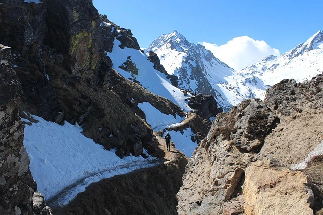
The Manaslu Base Camp Trek takes you through one of Nepal's most restricted and culturally preserved trekking corridors to the foot of Mount Manaslu (8,163m) — the eighth-highest mountain on Earth. This 14-day journey follows the Budhi Gandaki River valley through the Manaslu Conservation Area, passing through Nubri and Gurung villages where Tibetan Buddhist traditions remain largely untouched by mass tourism.

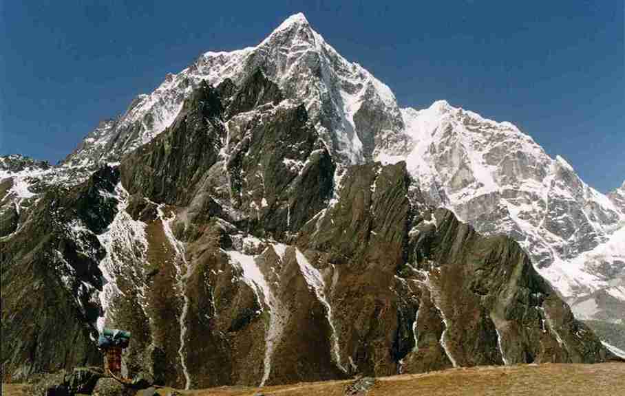
Unlike heavily trafficked routes in the Everest and Annapurna regions, the Manaslu region operates under restricted area regulations that limit trekker numbers and preserve authentic mountain culture. The trail culminates at Manaslu Base Camp (4,800m), where the mountain's massive north face and the Manaslu Glacier create one of the most dramatic high-altitude landscapes in the Nepal Himalaya.

What Makes This Trek Exceptional:

  • Close-range views of Mount Manaslu's north face and the Manaslu Glacier at 4,800m
  • Restricted area status ensures fewer trekkers and preserved Tibetan Buddhist culture
  • Passage through the deep Budhi Gandaki Gorge — one of Nepal's most dramatic river valleys
  • Traditional Nubri and Gurung villages with ancient monasteries and mani walls
  • Birendra Tal (glacial lake) near base camp offering stunning reflections of Manaslu
  • Off-the-beaten-path trekking with genuine cultural immersion
  • Manaslu Conservation Area biodiversity including snow leopard and Himalayan tahr habitat

This 14-day Manaslu Base Camp Trek itinerary balances efficient travel with adequate acclimatization, progressing from subtropical lowlands through alpine terrain to the glacial moraines beneath Manaslu's summit pyramid.

14-Day Itinerary Summary

Day Route Max Altitude
Day 1 Arrive Kathmandu 1,300m
Day 2 Drive Kathmandu → Soti Khola 710m
Day 3 Soti Khola → Machha Khola 869m
Day 4 Machha Khola → Jagat 1,340m
Day 5 Jagat → Deng 1,860m
Day 6 Deng → Namrung 2,630m
Day 7 Namrung → Lho 3,180m
Day 8 Lho → Samagaon 3,530m
Day 9 Acclimatization Day – Samagaon 3,530m
Day 10 Samagaon → Manaslu Base Camp → Samagaon 4,800m
Day 11 Samagaon → Lho 3,180m
Day 12 Lho → Jagat 1,340m
Day 13 Jagat → Soti Khola 710m
Day 14 Drive Soti Khola → Kathmandu 1,300m

Why Choose the Manaslu Base Camp Trek

Trekkers seeking genuine Himalayan adventure beyond the mainstream routes find the Manaslu Base Camp Trek delivers experiences that popular destinations cannot match. The restricted area status creates a trekking environment closer to what Nepal offered decades ago — before teahouse menus listed pizza and WiFi became standard.

The Manaslu Base Camp Advantage

Key Benefits of This Route:

  • Direct approach to the eighth-highest mountain without the crowds of Everest Base Camp
  • Restricted area regulations preserve authenticity and limit trail traffic
  • Deep cultural immersion in traditional Tibetan Buddhist communities
  • Diverse terrain from tropical river valleys to glacial moraines
  • Samagaon acclimatization provides safe altitude preparation
  • No domestic flights required — ground transportation from Kathmandu

Who Should Choose This Trek

Ideal for: Intermediate to experienced trekkers, cultural enthusiasts, photographers seeking uncrowded mountain landscapes, trekkers wanting restricted area experience

Consider alternatives if: No prior high-altitude experience above 3,500m, unable to commit 14 days, prefer well-developed teahouse infrastructure, uncomfortable with basic mountain accommodation

Why Choose this trek

Factor Manaslu Base Camp High-Traffic Treks
Annual Trekkers ~3,000 30,000-50,000
Trail Traffic Very Low Moderate to High
Cultural Authenticity High Moderate
Difficulty Grade Moderate to Strenuous Moderate

Manaslu Conservation Area: The Restricted Mountain Corridor

The Manaslu Conservation Area encompasses 1,663 square kilometers across Gorkha District in northern Nepal, bordering Tibet to the north. Established in 1998 and managed by the National Trust for Nature Conservation (NTNC), the conservation area protects the Budhi Gandaki watershed and surrounding peaks from 600m to Manaslu's summit at 8,163m.

Conservation Area Facts:

  • Total area: 1,663 sq km
  • Elevation range: 600m to 8,163m
  • Location: Gorkha District, Gandaki Province
  • Biodiversity: 2,000+ plant species, 110 bird species, 33 mammal species
  • Notable wildlife: Snow leopard, Himalayan tahr, blue sheep, red panda, Himalayan monal

The Budhi Gandaki Valley — the central corridor of this trek — cuts one of the deepest gorges in the Nepal Himalaya, hosting 11 distinct forest types from subtropical sal to alpine meadow.

Manaslu Base Camp Trek Difficulty Assessment

The Manaslu Base Camp Trek rates as moderate to strenuous, primarily due to the base camp day hike's significant elevation gain and the cumulative effect of 12 consecutive trekking days.

Difficulty by Section

Days 2-5 (Soti Khola to Deng): Moderate River valley trekking with constant undulation. Suspension bridge crossings and rocky terrain require attention but altitude remains manageable below 2,000m.

Days 6-8 (Deng to Samagaon): Moderate to Challenging Significant altitude gains as the trail climbs from 1,860m to 3,530m. Pace must slow. Acclimatization awareness becomes critical.

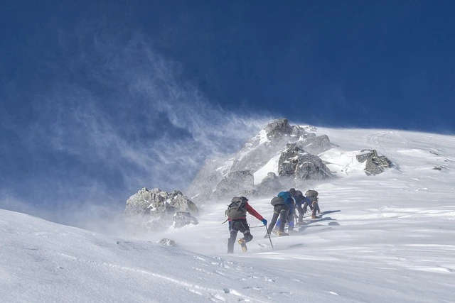
Day 10 (Base Camp Day): Strenuous The single-day climb of 1,270m to 4,800m over loose moraine and glacial debris represents the trek's hardest day. Fitness and acclimatization directly determine success.

Days 11-13 (Descent): Moderate Long descent days demanding knee strength. Cumulative fatigue from 10+ trekking days is a factor.

Physical Fitness Requirements

  • Cardiovascular endurance for 5-8 hours daily walking
  • Leg strength for steep climbs and descents
  • Ability to carry a 5-7kg daypack over rough terrain
  • Prior trekking experience above 3,500m strongly recommended
  • Pre-trek training: 8-12 weeks of hiking, stair climbing, and cardiovascular exercise

Altitude Profile and Acclimatization Strategy

Altitude management is the single most important safety factor on the Manaslu Base Camp Trek. The itinerary incorporates a strategic acclimatization day at Samagaon (Day 9) before the base camp ascent.

Altitude Profile

Location Altitude Risk Level
Soti Khola 710m None
Jagat 1,340m None
Deng 1,860m None
Namrung 2,630m Low
Lho 3,180m Moderate
Samagaon 3,530m Moderate
Manaslu Base Camp 4,800m High

Acclimatization Protocols

The itinerary limits sleeping altitude gain to 400-550m per day above 2,500m. The base camp day returns to 3,530m for sleeping — applying the climb-high, sleep-low principle.

  • Hydration: 3-4 liters daily above 3,000m
  • Pace: Slow and steady, rest breaks every 45-60 minutes
  • Nutrition: High-carbohydrate meals, avoid alcohol
  • Diamox: Consider prophylactic use (consult doctor before trek)
  • Monitoring: Guide checks symptoms twice daily above 3,000m

Warning signs requiring immediate attention: Persistent severe headache, vomiting, loss of coordination, confusion, breathlessness at rest.

Best Time for Manaslu Base Camp Trek

The Manaslu region's weather patterns create two optimal trekking windows with distinct characteristics.

Autumn Season (September – November) — BEST

October is the peak month for the Manaslu Base Camp Trek. Post-monsoon clarity delivers crystal-clear mountain views, stable weather patterns, and comfortable daytime temperatures. Nights grow cold above 3,000m, but trail conditions are excellent.

Spring Season (March – May) — EXCELLENT

April and May offer warmer temperatures and rhododendron forests in spectacular bloom between 2,500m and 3,500m. Occasional afternoon clouds may obscure views, but mornings are typically clear.

Seasdonal Comparision

Factor Autumn (Sep-Nov) Spring (Mar-May)
Visibility Excellent Good (morning best)
Daytime Temps 10-20°C (lower), 0-10°C (upper) 12-22°C (lower), 2-12°C (upper)
Rainfall Minimal Occasional afternoon
Flora Green landscapes Rhododendron bloom
Trail Traffic Low-Moderate Low

Avoid: Monsoon season (June-August) brings heavy rainfall, landslide risk, leeches at lower elevations, and poor visibility. Winter (December-February) brings extreme cold, possible snowfall above 3,000m, and some teahouse closures.

Manaslu Base Camp Trek Permits and Regulations

The Manaslu region operates under Nepal's restricted area system, requiring specific permits and mandatory guide arrangements.

Required Permits

Permit Cost Issuing Authority
Manaslu Restricted Area Permit (MRAP) USD $100/week (peak) / $75/week (off-peak) Department of Immigration
Manaslu Conservation Area Permit (MCAP) NPR 3,000 (~$23) NTNC
TIMS Card NPR 2,000 (~$15) Nepal Tourism Board

Total permit cost: Approximately USD $135-150 per person (included in package price).

2026 Regulations

  • Solo trekking banned: Minimum two trekkers plus one licensed guide
  • Licensed guide mandatory: Registered with Nepal Tourism Board
  • Registered agency required: Permits only issued through authorized agencies
  • Required documents: Valid passport (6+ months), Nepal visa, passport photos, travel insurance

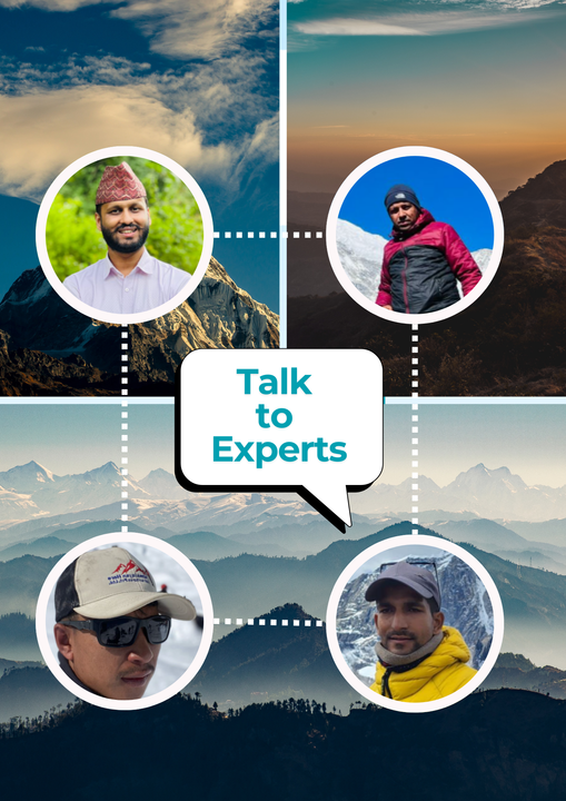
The Role of Guides and Porters in the Manaslu Region

In the Manaslu restricted area, a licensed guide is a legal requirement. Beyond compliance, experienced local guides transform the trekking experience in this remote region.

Navigation and safety: The Budhi Gandaki Valley trail includes unmarked junctions, seasonal river crossings, and sections without clear path marking. Guides who trek this route regularly know current conditions and weather patterns.

Altitude management: Experienced guides monitor altitude sickness symptoms, adjust pace individually, and make critical decisions about proceeding or descending — particularly valuable on the base camp day hike.

Cultural access: Guides from the Manaslu region speak local languages, understand monastery protocols, and maintain village relationships that create encounters unavailable to independent travelers.

  • Guide qualifications: NTB licensed, wilderness first aid trained, Manaslu region experience
  • Porter support: 1 porter per 2 trekkers, 20kg maximum load, fair wages guaranteed
  • Emergency protocols: Satellite communication, evacuation coordination, nearest health post knowledge


Accommodation and Food on the Trail

Teahouse accommodation along the Manaslu Base Camp Trek is basic but functional — simple twin rooms with foam mattresses, shared bathrooms, and communal dining areas heated by wood or yak-dung stoves.

Below 2,500m (Soti Khola to Deng): Hot showers, device charging, varied menus available.

2,500m to 3,500m (Namrung to Samagaon): Limited hot water, expensive charging. Samagaon offers the best upper valley facilities — multiple lodges and a small bakery.

Base Camp Day (4,800m): No facilities. Pack lunch from Samagaon, carry adequate water, and return to Samagaon overnight.

Food and Nutrition

Dal bhat — Nepal's staple of rice, lentil soup, vegetables, and pickles — is the foundation of trekking nutrition with unlimited refills.

  • Dal bhat: Best value, freshest ingredients, unlimited refills
  • Alternatives: Fried rice, noodles, pasta, pancakes, porridge
  • Altitude nutrition: High-carbohydrate meals above 3,000m, avoid meat at elevation
  • Garlic soup: Local remedy believed to aid altitude acclimatization

Packing Essentials for Manaslu Base Camp Trek

The elevation range (710m to 4,800m) demands layered clothing for temperatures ranging from 25°C to -10°C. Key items: layered clothing system (base, fleece/down, waterproof shell), broken-in trekking boots, down jacket, sleeping bag rated to -10°C, trekking poles, daypack, headlamp, sun protection (sunglasses, SPF 50+), water bottles with purification, first aid basics, and all permit documents in waterproof storage.

Why Choose Himalayanhero for Manaslu Base Camp Trek

For restricted area treks like Manaslu Base Camp, operator selection directly impacts safety and experience quality.

  • Guides with multiple Manaslu completions who understand the Budhi Gandaki Valley
  • Established relationships with the Nubri and Gurung communities along the route
  • Emergency communication equipment and helicopter evacuation protocols
  • Fair porter treatment and responsible tourism practices
  • NTB licensed guides, TAAN registered agency, 24/7 Kathmandu support

Book Your Manaslu Base Camp Trek

The Manaslu Base Camp Trek delivers genuine remoteness, profound cultural immersion, and the privilege of standing at the foot of an 8,000-meter peak with few other trekkers in sight.

USD $1,049 per person | 14 Days | All permits and guiding included

📧 [email protected]
📱 WhatsApp: +977 9801127073
🌐 himalayanhero.com

Itinerary


Day 1 Arrival in Kathmandu (1,350m) – Preparation Day

Your Manaslu Base Camp Trek begins with arrival at Tribhuvan International Airport. Our representative transfers you to your hotel. The evening includes a trek briefing covering restricted area regulations, gear verification, and altitude management strategy.

Day 1 Details:

  • Airport pickup and hotel transfer
  • Trek briefing, gear inspection, permit review
  • Guide and team introduction

Day 2 Drive from Kathmandu to Machha Khola (869m) – 7–8 hours

The drive follows the Prithvi Highway before turning north toward the Manaslu region. The road grows rougher as you leave the highway, requiring a 4WD vehicle for the final section into the Budhi Gandaki Valley. Machha Khola sits along the river at the start of the trekking corridor.

Day 2 Details:

  • Drive duration: 7-8 hours (highway then rough 4WD track)
  • Altitude: 869m
  • Terrain transition: Urban to river valley
  • Accommodation: Teahouse at Machha Khola

Day 3 Machha Khola to Jagat (1,340m) – 6–7 hours

The first trekking day follows the Budhi Gandaki River through subtropical forest, crossing suspension bridges and passing through small villages. The trail weaves along the gorge walls with waterfalls cascading from cliffs above. Jagat marks the official entry point into the Manaslu restricted area — your guide processes permit verification at the checkpoint here.

  • Permit checkpoint: Restricted area verification at Jagat
  • River crossings: Multiple suspension bridges
  • Cultural shift: First mani walls and prayer flags appear
  • Terrain: River trails, stone steps, forest paths

Day 4 Jagat to Deng (1,860m) – 7–8 hours

Beyond Jagat, the Budhi Gandaki Valley begins to open. The trail passes through Philim — a significant Gurung village where terraced farmland climbs steep hillsides. Traditional stone houses with slate roofs reflect centuries of adaptation to this vertical landscape.

The section between Philim and Deng transitions from Gurung to increasingly Tibetan cultural influence. Mani walls grow longer, prayer wheels appear at trail junctions, and the architecture shifts toward flat-roofed Tibetan-style structures.

  • Gurung culture: Philim village — terraced farms, traditional stone houses
  • Cultural transition: Gurung influence gives way to Tibetan Buddhist elements
  • River scenery: Budhi Gandaki widens, valley opens
  • Altitude note: Moderate gain, body adjusting to trekking rhythm

Day 4 Details:

  • Trek duration: 7-8 hours
  • Elevation gain: +520m
  • Villages: Philim, Ekle Bhatti, Deng
  • Accommodation: Teahouse at Deng

Day 5 Deng to Namrung (2,630m) – 6–7 hours

A significant altitude gain day as the trail climbs through changing vegetation zones. Pine and rhododendron forests replace subtropical species. The valley transforms — wider vistas, snow-capped peaks emerging above ridgelines, and the air noticeably cooler.

Namrung is a traditional Nubri village where Tibetan Buddhist culture is fully established. Ancient chortens guard village entrances, prayer flags span the valley, and monastery bells mark evening prayers. The Shringi Himal (7,161m) becomes visible from surrounding ridges.

  • Altitude gain: Most significant climb so far (+770m)
  • Vegetation change: Subtropical to temperate — rhododendron and pine forests appear
  • Mountain views: Shringi Himal (7,161m) first appears
  • Nubri culture: Traditional flat-roofed houses, prayer flags, chortens

Day 5 Details:

  • Trek duration: 6-7 hours
  • Elevation gain: +770m
  • Cultural highlight: Enter Nubri region — Tibetan Buddhist heartland
  • Accommodation: Teahouse at Namrung

Day 6 Namrung to Shyala (3,500m) – 4–5 hours

A shorter day allows the body to adjust as you climb into the high alpine zone. The trail passes through Lho village, where the Ribung Monastery commands panoramic views of Mount Manaslu's massive north face — the first location where the mountain's full scale becomes apparent.

Beyond Lho, the landscape opens further as the valley widens toward Shyala. Mountain views improve steadily with Manaslu (8,163m) and Himalchuli (7,893m) dominating the skyline.

  • Mount Manaslu first view: The eighth-highest mountain appears in full profile
  • Ribung Monastery: Historic Buddhist monastery above Lho village
  • Altitude adjustment: Pace slows, hydration becomes critical
  • Photography: One of the best Manaslu viewpoints on the entire trek

Day 6 Details:

  • Trek duration: 4-5 hours
  • Elevation gain: +870m
  • Mountain views: Manaslu (8,163m), Himalchuli (7,893m)
  • Accommodation: Teahouse at Shyala

Day 7 Shyala to Samagaon (3,530m) via Pungyen Monastery

Today's route passes beneath Manaslu's north face with a visit to Pungyen Gompa — a remote Buddhist monastery set against glacial terrain with commanding views of the Manaslu massif. This is one of the most spiritually significant sites in the upper Budhi Gandaki Valley.

Samagaon is the main village of the upper Manaslu region. Traditional flat-roofed stone houses cluster around the monastery, yak herding remains the primary livelihood, and the village functions as a trading post on the ancient trans-Himalayan route between Nepal and Tibet. Samagaon offers the best facilities before the high country — multiple lodge options, a small bakery, and charging stations.

  • Pungyen Gompa: Important Buddhist monastery with Manaslu panorama
  • Samagaon: Largest upper valley settlement, best facilities
  • Yak herding: Traditional livestock visible on surrounding pastures
  • Base camp preparation: Acclimatization base for the 4,800m hike

Day 7 Details:

  • Trek duration: 3-4 hours
  • Elevation: 3,530m (slight descent from Shyala)
  • Cultural highlight: Pungyen Gompa monastery visit
  • Facilities: Best lodges, bakery, charging available
  • Accommodation: Teahouse at Samagaon

Day 8 Acclimatization Day – Manaslu Base Camp Hike (4,800m)

The defining day of this trek. A challenging acclimatization hike from Samagaon to Manaslu Base Camp at 4,800m climbs 1,270 meters over moraines and glacial terrain, returning the same day.

The trail follows the lateral moraine of the Manaslu Glacier through increasingly barren terrain. Rocky paths give way to glacial debris as alpine meadow transforms into high-altitude moonscape. At base camp, the north face of Mount Manaslu towers directly overhead — an ice-armored wall rising over 3,000 meters from glacier to summit. Birendra Tal (glacial lake) near the approach reflects Manaslu's face in still morning conditions.

This hike is demanding but highly beneficial for safety — the altitude exposure significantly improves the body's adaptation for the higher elevations ahead.

  • Summit altitude: 4,800m — Manaslu Base Camp
  • Elevation gain: +1,270m from Samagaon (significant single-day climb)
  • Manaslu Glacier: Walk along lateral moraine to glacier's edge
  • Birendra Tal: Glacial lake with stunning mountain reflections
  • No facilities: Pack lunch from Samagaon, carry 3-4 liters water

Day 9 Samagaon to Samdo (3,875m) – 2–3 hours

A deliberately short walking day allows recovery after the base camp hike. The trail continues up the Budhi Gandaki Valley as the landscape becomes more barren and the Tibetan borderlands draw closer. Rocky terrain replaces forest, and the cultural atmosphere shifts toward a more remote, frontier character.

Samdo is one of the highest permanent settlements in the valley. Traditional stone houses built close together reflect both the harsh climate and the community's centuries-old trading connections with Tibet.

  • Recovery day: Short distance after demanding base camp hike
  • Landscape shift: Barren, high-altitude terrain near Tibetan border
  • Samdo village: Historic trans-Himalayan trading settlement
  • Altitude preparation: Body continues adapting at higher sleeping elevation

Day 9 Details:

  • Trek duration: 2-3 hours
  • Elevation gain: +345m
  • Terrain: High alpine valley, rocky paths
  • Accommodation: Teahouse at Samdo

Day 10 Acclimatization Day – Tibetan Border Hike

An optional hike toward the Tibetan border viewpoint provides further acclimatization and a chance to explore the remote landscape beyond Samdo. The rest of the day is dedicated to rest and preparation for the high-altitude days ahead.

This second acclimatization day exists specifically to reduce altitude sickness risk before the ascent to Dharamsala and the Larkya La Pass crossing. Rushing this section is the most common mistake on this trek.

  • Border viewpoint: Optional hike toward Tibet for panoramic views
  • Risk reduction: Further acclimatization before 4,460m+ sleeping altitude
  • Preparation: Gear check, energy conservation for pass day
  • Hydration focus: 3-4 liters minimum fluid intake

Day 10 Details:

  • Trek duration: Optional hike (2-4 hours)
  • Altitude: 3,875m (sleep altitude)
  • Purpose: Critical acclimatization before high pass
  • Health note: Guide monitors all trekkers for altitude symptoms

Day 11 Samdo to Dharamsala (4,460m) – 3–4 hours

A gradual ascent to Dharamsala — the high camp at the base of Larkya La Pass. The landscape is stark and beautiful: rock, ice, and sky with no vegetation above the sparse alpine scrub left behind below 4,000m.

Accommodation at Dharamsala is basic — stone shelters with minimal facilities. An early night is essential as the pass crossing begins before dawn the next morning. Your guide briefs the team on the pass-day protocol, weather assessment, and pacing strategy.

  • High camp: Highest sleeping point of the entire trek (4,460m)
  • Basic accommodation: Stone shelter, no showers, limited menu
  • Pass preparation: Guide briefs team on next-day strategy
  • Early sleep: 7:00-8:00 PM recommended for pre-dawn start

Day 11 Details:

  • Trek duration: 3-4 hours
  • Elevation gain: +585m
  • Terrain: Barren alpine, rocky ascent
  • Accommodation: Basic stone shelter at Dharamsala

Day 12 Cross Larkya La Pass (5,160m) to Bhimtang (3,590m)

The most challenging and rewarding day of the Manaslu Base Camp Trek. Starting before dawn, the trail climbs steadily to Larkya La Pass at 5,160m — the highest point of the journey. The ascent crosses glacial moraines and snow patches, with prayer flags marking the pass summit where 360-degree Himalayan panoramas stretch across the Manaslu and Annapurna ranges.

The descent from the pass is steep and demanding, dropping over 1,500 meters to the alpine meadows of Bhimtang. The contrast is dramatic — from stark, frozen high altitude to green pastures with views of Manaslu's southern flanks.

  • Larkya La Pass: 5,160m — highest point, prayer flags at summit
  • Panoramic views: Manaslu, Himalchuli, Annapurna II visible
  • Conditions: Cold, potentially windy, snow patches possible
  • Descent: Steep 1,570m drop to Bhimtang

Day 12 Details:

  • Trek duration: 7-9 hours
  • Elevation gain: +700m, then descent -1,570m
  • Max altitude: 5,160m (Larkya La Pass)
  • Start time: 3:00-4:00 AM
  • Terrain: Glacial moraine, snow patches, steep descent
  • Accommodation: Teahouse at Bhimtang

Day 13 Bhimtang to Tilje (2,300m) – 5–6 hours

A long descent through forests and river valleys brings warmer air and greener scenery as you leave the high alpine zone behind. The trail passes through rhododendron and pine forests before entering the Marsyangdi River valley with its terraced farmland and lower-elevation villages.

The physical relief of descending below 3,000m is noticeable — warmer temperatures, richer oxygen, and the return of familiar vegetation create a sense of completion.

  • Elevation relief: Drop below 3,000m for the first time in a week
  • Vegetation return: Forests, farmland, warmer climate
  • Trail condition: Well-maintained descent through village paths
  • Celebration mood: Final trekking day atmosphere

Day 13 Details:

  • Trek duration: 5-6 hours
  • Elevation loss: -1,290m
  • Terrain: Forest trails, village paths, river valley
  • Accommodation: Teahouse at Tilje

Day 14 Drive from Tilje to Kathmandu – 8–9 hours

After breakfast, the return drive follows the Marsyangdi Valley road to the highway and back to Kathmandu. Arrival in the capital by late afternoon marks the conclusion of your Manaslu Base Camp Trek. A farewell dinner in the evening provides a chance to reflect on the journey.

Day 14 Details:

  • Drive duration: 8-9 hours
  • Farewell dinner in Kathmandu
  • Trip concludes upon hotel/airport drop-off

Inclusion

  • Airport - hotel -airport pickup and drop by private vehicle in Kathmandu.
  • Meals on full board (Breakfast, lunch and dinner) during trekking period.
  • 13 Nights accommodations during the trek in a tea house
  • An experienced Government-licensed guide.
  • Food, drinks, accommodation, insurance, salary, equipment, transportation, local tax for guides and porters.
  • All local transportation by bus and Jeep before and after the trek
  • All necessary permits and special paperwork
  • All government taxes and our service charges.


Extra Supplement By Himalayan Hero

  • Group medical supplies (First Aid kit).
  • Sleeping Bag if required
  • Himalayan Hero Cap
  • Duffle Bag for Potter
  • Farewell Dinner before departure
  • Seasonal Fruit in the evening for Dessert
  • Manaslu and Tsum Valley area Trekking map
  • Trek Achievement Certificate.

Exclusion

Exclusion

  • Personal trekking Equipment.
  • Potter to carry your bags ( 230 USD for 1 Potter, 14 days)
  • Tips, drinks, and personal expenses
  • Client Travel Insurance

FAQs about travel in himalayanhero.com

How difficult is the Manaslu Base Camp Trek?

The trek rates moderate to strenuous overall. Most trekking days involve 5-7 hours of walking on varied terrain. The base camp day hike (Day 8) climbs 1,270m to 4,800m over loose moraine, and the Larkya La Pass crossing (Day 12) at 5,160m is the most physically demanding day. Prior trekking experience above 3,500m is strongly recommended.

Is Manaslu Base Camp Trek suitable for beginners?

This trek is best suited for intermediate trekkers with previous multi-day hiking experience. The Larkya La Pass crossing at 5,160m and the base camp hike to 4,800m demand solid fitness and altitude awareness. Fit beginners with 8-12 weeks of dedicated preparation and prior experience above 3,000m can complete the trek, but it should not be your first Himalayan trek.

How many days does the Manaslu Base Camp Trek take?

This itinerary covers 14 days including two drive days and two acclimatization days (base camp hike and Tibetan border hike). The trek involves 10 trekking days and 2 driving days.

What is the best time to trek Manaslu Base Camp?

October and November (autumn) offer the best conditions — clear skies, stable weather, and excellent mountain views. April and May (spring) provide warmer temperatures and rhododendron blooms.

How much does the Manaslu Base Camp Trek cost?

Our all-inclusive 14-day package is USD $1,049 per person, covering permits, transportation, accommodation, meals, guide, and porter. Budget an additional $150-250 for personal expenses.

Can I trek Manaslu Base Camp without a guide?

No. The Manaslu region is a restricted area requiring a licensed guide, a minimum of two trekkers, and permits issued through a registered trekking agency. Independent trekking is prohibited.

What altitude does Manaslu Base Camp reach?

Manaslu Base Camp sits at 4,800 meters (15,748 feet), reached as a day hike from Samagaon. The trek's overall highest point is Larkya La Pass at 5,160m (16,929 feet). The route starts at 869m (Machha Khola) and gains over 4,000 meters total elevation across the journey.

How do I prevent altitude sickness on this trek?

The itinerary includes two dedicated acclimatization days — the base camp hike from Samagaon (Day 8) and the Tibetan border hike from Samdo (Day 10). This progressive altitude exposure is specifically designed for safe Larkya La crossing. Stay hydrated (3-4 liters daily), maintain a slow pace, eat high-carbohydrate meals, and report any symptoms to your guide immediately.

Is Manaslu Base Camp Trek less crowded than Everest Base Camp?

Significantly. The Manaslu region receives approximately 3,000 trekkers annually compared to 50,000+ at Everest Base Camp. Restricted area regulations and limited infrastructure keep numbers low, preserving an authentic mountain experience.

What is the difference between Manaslu Base Camp and Everest Base Camp Trek?

Manaslu Base Camp reaches 4,800m compared to Everest Base Camp's 5,364m. Manaslu offers stronger cultural immersion in Tibetan Buddhist villages, far fewer trekkers, and restricted area exclusivity. Everest offers higher altitude, more developed infrastructure, and the iconic Khumbu Valley experience.

Customer Reviews


R

Rachel Thornton – Canada

""The Manaslu Base Camp Trek exceeded every expectation. Standing at 4,800m with Manaslu's north face towering overhead was the most humbling moment of my life. The Budhi Gandaki Valley felt untouched compared to busier trails. Our guide from Himalayan Hero knew every village, every monastery, every safe water source. Samagaon village alone was worth the journey. This is Nepal trekking as it should be.""

Feb. 25, 2024

H

Henrik Solberg – Norway

""I have trekked Everest Base Camp and Annapurna, but Manaslu Base Camp Trek felt completely different. Fewer trekkers, stronger cultural immersion, and landscapes that changed dramatically every single day. The acclimatization day hike to base camp was demanding but incredibly rewarding. Pungyen Gompa monastery above Samagaon offered the best mountain views I have seen anywhere. Himalayan Hero handled every permit and logistic perfectly.""

June 10, 2024

P

Priya Sharma – India

""Crossing Larkya La Pass at sunrise was the most beautiful moment of my trekking career. The Manaslu Base Camp Trek combines remote wilderness with genuine Tibetan Buddhist culture in ways that popular routes simply cannot match. Our Himalayan Hero guide monitored altitude carefully and adjusted our pace through Samdo and Dharamsala. The restricted area status keeps this trek authentic. Highly recommended for experienced trekkers.""

Dec. 15, 2024

USD 1049.00 per person

Secure Your Booking with Just 10% Down!