The Everest Base Camp Map and Elevation help you understand the complete trekking route before you begin your adventure. The trail starts in Lukla at 2,860 meters (9,383 feet) and follows the famous Khumbu Valley to Everest Base Camp at 5,364 meters (17,598 feet). Many trekkers continue to Kala Patthar at 5,545 meters (18,192 feet), the highest point on the standard itinerary and the best place to enjoy panoramic views of Mount Everest.
Everest Base Camp Trek at a Glance
- Starting point: Lukla (2,860 m), reached by a 35-minute flight from Kathmandu
- Destination: Everest Base Camp (5,364 m)
- Highest point: Kala Patthar (5,545 m)
- Total trekking distance: Approximately 130 km (round trip)
- Typical duration: 14 days, including two acclimatization days
Studying the Everest Base Camp Map and Elevation before your trip helps you understand where the trail climbs, where it becomes easier to walk, and where altitude begins to affect your body. It also shows the location of important villages, acclimatization stops, suspension bridges, and major landmarks. With a clear understanding of the route and daily elevation profile, you can prepare properly, manage your pace, and enjoy a safer and more rewarding trek to Everest Base Camp.
📅 Book your place on the Everest Base Camp Trek 14 Days and make your Everest dream a reality.
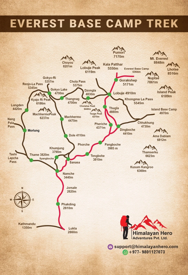
Where Is Everest Base Camp Located on the Map?
Everest Base Camp is located inside Sagarmatha National Park in Nepal's Khumbu region, approximately 160 kilometers northeast of Kathmandu. Sitting on the Khumbu Glacier at an elevation of 5,364 meters (17,598 feet), it serves as the starting point for climbers attempting to summit Mount Everest from the south side. For trekkers, it marks the end of one of the world's most iconic hiking routes.
Although many people imagine Everest Base Camp directly beneath Everest's summit, the mountain itself remains hidden from the campsite because of surrounding ridges and glacial terrain. This is why most trekkers continue to Kala Patthar, where the panoramic views of Everest, Nuptse, Pumori, and the Khumbu Glacier are among the finest in the Himalayas. Understanding this layout through an Everest Base Camp map with villages helps visitors appreciate how the landscape unfolds throughout the trek.
Key Locations Along the Route
| Location |
Elevation |
| Kathmandu |
1,400 m |
| Lukla |
2,860 m |
| Namche Bazaar |
3,440 m |
| Tengboche |
3,860 m |
| Dingboche |
4,410 m |
| Lobuche |
4,910 m |
| Gorak Shep |
5,164 m |
| Everest Base Camp |
5,364 m |
| Kala Patthar |
5,545 m |
Understanding the Everest Base Camp Trekking Map
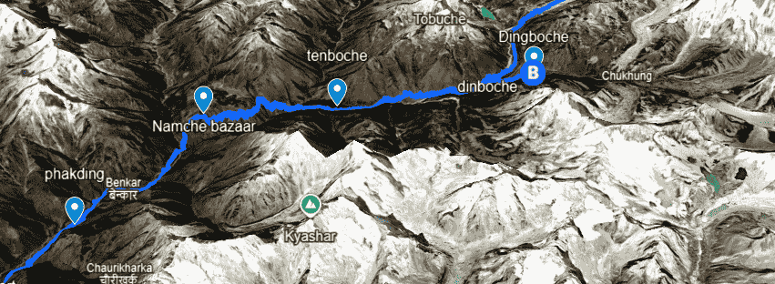
A detailed Everest Base Camp trekking map reveals that the journey is much more than a steady climb toward the world's highest mountain. The trail rises and falls repeatedly, following river valleys, crossing deep gorges, and climbing forested hills before reaching the high alpine landscape of the Khumbu Glacier. Knowing these changes helps trekkers pace themselves rather than focusing only on altitude.
Modern maps also provide practical navigation tools. Many trekkers now download an interactive Everest Base Camp map, an Everest Base Camp GPS map, or an Everest Base Camp route map PDF before leaving Kathmandu. Offline navigation apps are especially useful because mobile coverage becomes less reliable at higher elevations. Even when trekking with a guide, having your own map gives you confidence and helps you understand each day's destination.
Features Found on Most Trekking Maps
Most reliable maps include:
- Lukla to Everest Base Camp trail map
- Village locations
- Daily trekking distances
- Elevation profile
- Rivers and suspension bridges
- Monasteries
- National park checkpoints
- Emergency helicopter landing areas
- Tea houses
- Viewpoints and mountain peaks
Expert Tip: Download your offline GPS map before flying to Lukla. Internet access is available in Kathmandu, but connections become slower and less reliable as you move higher into the Everest region.
Everest Base Camp Route Overview
The Everest Base Camp route follows a well-established trail through the Khumbu Valley, making navigation relatively simple compared with many remote Himalayan treks. Starting in Lukla, the route gradually climbs north through Sherpa villages, alpine forests, glacial valleys, and rocky moraines before reaching Everest Base Camp. Most itineraries take 12 to 14 days, allowing enough time for acclimatization while enjoying the spectacular scenery.
Although the route is clearly marked, every section presents different challenges. Lower elevations feature stone paths, forests, and suspension bridges, while the upper trail becomes rockier and more exposed. The final approach from Gorak Shep to Everest Base Camp crosses the Khumbu Glacier's uneven moraine, requiring careful footing despite the relatively short distance. Understanding the Everest Base Camp trail map beforehand helps trekkers prepare for these changing conditions.
Standard Everest Base Camp Route
| Stage |
Elevation |
Average Walking Time |
| Lukla → Phakding |
2,610 m |
3–4 hrs |
| Phakding → Namche Bazaar |
3,440 m |
6 hrs |
| Acclimatization Day |
Namche Bazaar |
Day hike |
| Namche → Tengboche |
3,860 m |
5 hrs |
| Tengboche → Dingboche |
4,410 m |
5–6 hrs |
| Acclimatization Day |
Dingboche |
Day hike |
| Dingboche → Lobuche |
4,910 m |
5 hrs |
| Lobuche → Gorak Shep → Everest Base Camp |
5,364 m |
7–8 hrs |
| Gorak Shep → Kala Patthar |
5,545 m |
2–3 hrs |
Which Villages Are on the Everest Base Camp Trail?
The Everest Base Camp villages are more than overnight stops. Each settlement plays an important role in helping trekkers adjust to increasing altitude while offering a glimpse into Sherpa culture, Himalayan traditions, and mountain hospitality. Every village has its own landscape, pace, and significance, making the journey just as memorable as reaching Base Camp itself.
As you follow the Everest trekking route, you'll notice dramatic changes in both scenery and lifestyle. Dense forests gradually give way to open alpine valleys, while traditional stone houses become more widely spaced as the altitude increases. Tea houses provide warm meals, comfortable accommodation, and valuable opportunities to rest before continuing toward higher elevations.
Main Villages on the Everest Base Camp Route
- Lukla (2,860 m): Gateway to the Everest region.
- Phakding (2,610 m): Gentle first-day walk beside the Dudh Koshi River.
- Namche Bazaar (3,440 m): The largest Sherpa town and key acclimatization stop.
- Tengboche (3,860 m): Home to the famous Tengboche Monastery.
- Dingboche (4,410 m): Wide alpine valley and second acclimatization stop.
- Lobuche (4,910 m): Small mountain settlement near the Khumbu Glacier.
- Gorak Shep (5,164 m): Final overnight stop before Everest Base Camp and Kala Patthar.
Did You Know? Namche Bazaar has been an important trading center for centuries. Today, it remains the cultural and economic heart of the Khumbu region, where trekkers can visit museums, bakeries, gear shops, and viewpoints offering their first clear views of Mount Everest
Everest Base Camp Elevation by Day: Understanding the Altitude Profile
One of the biggest challenges on the Everest Base Camp trek is not the walking distance but the steady increase in altitude. The Everest Base Camp altitude profile shows that you climb from Lukla at 2,860 meters (9,383 feet) to Everest Base Camp at 5,364 meters (17,598 feet) over several days. This gradual ascent is carefully planned to help your body adapt to thinner air and reduce the risk of altitude sickness.
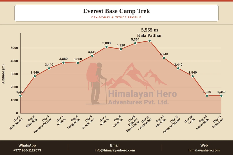
A well-designed itinerary balances daily elevation gain with planned acclimatization. Rather than climbing as quickly as possible, experienced guides recommend spending extra nights in Namche Bazaar and Dingboche. These scheduled stops allow your body to produce more red blood cells, making it easier to cope with reduced oxygen levels as you move higher into the Khumbu region.
Everest Base Camp Elevation Chart
The following Everest Base Camp elevation chart gives you a clear overview of the altitude at each major stop. Many trekkers save this chart before their trip because it makes it easier to visualize daily progress and prepare for the most demanding sections of the trek.
| Location |
Elevation (Meters) |
Elevation (Feet) |
| Kathmandu |
1,400 m |
4,593 ft |
| Lukla |
2,860 m |
9,383 ft |
| Phakding |
2,610 m |
8,563 ft |
| Namche Bazaar |
3,440 m |
11,286 ft |
| Tengboche |
3,860 m |
12,664 ft |
| Dingboche |
4,410 m |
14,469 ft |
| Lobuche |
4,910 m |
16,109 ft |
| Gorak Shep |
5,164 m |
16,942 ft |
| Everest Base Camp |
5,364 m |
17,598 ft |
| Kala Patthar |
5,545 m |
18,192 ft |
Key Highlights
- Everest Base Camp elevation: 5,364 meters
- Everest Base Camp altitude: 17,598 feet
- Highest point of the trek: Kala Patthar (5,545 meters)
- Total elevation gain from Lukla: Approximately 2,500 meters
- Recommended trek duration: 12 to 14 days
Expert Tip: Save this elevation chart on your phone or print a copy before your trek. Knowing your sleeping altitude each night helps you monitor your progress and recognize when you're entering the higher-risk altitude zone.
What Is the Exact Elevation of Everest Base Camp?
The exact elevation of Everest Base Camp on the Nepal side is 5,364 meters (17,598 feet) above sea level. This is the official altitude used by trekking companies, guidebooks, and the Nepal Tourism Board. At this height, the air contains roughly half the oxygen available at sea level, making proper acclimatization essential for every trekker, regardless of age or fitness level.
Many people confuse Everest Base Camp with the summit of Mount Everest, but the difference is significant. Base Camp is where climbing expeditions establish their temporary camps before attempting the ascent through the Khumbu Icefall. Trekkers finish their journey here, enjoy the dramatic glacier views, and then return to Gorak Shep. Those seeking the best view of Everest continue to Kala Patthar, which stands 181 meters higher than Base Camp and offers an unobstructed panorama of the surrounding Himalayan peaks.
Everest Base Camp in Meters and Feet
- Altitude: 5,364 meters
- Height: 17,598 feet
- Region: Khumbu, Nepal
- National Park: Sagarmatha National Park
- Mountain Range: Himalayas at Mahalangur Himalayan Range
How High Is Everest Base Camp in Feet?
For travelers using imperial measurements, Everest Base Camp stands at 17,598 feet above sea level. At this elevation, oxygen levels are approximately 50 percent lower than at sea level, which explains why trekkers often experience slower walking speeds, increased breathing rates, and occasional headaches during the final stages of the journey.
Understanding the altitude in both feet and meters is useful when comparing Everest Base Camp with other famous trekking destinations. While many high-altitude hikes around the world exceed 4,000 meters, few combine the dramatic elevation, glacier landscape, and iconic mountain scenery found along the Everest trekking route. This unique combination is one of the reasons the trek remains on the bucket list of hikers from around the globe.
Elevation Comparison
| Destination |
Elevation |
| Everest Base Camp |
17,598 ft |
| Kala Patthar |
18,192 ft |
| Kilimanjaro Summit |
19,341 ft |
| Annapurna Base Camp |
13,550 ft |
How Many Kilometers Is the Everest Base Camp Trek?
The classic Everest Base Camp trek covers approximately 130 kilometers (80 miles) round trip, although the exact distance depends on your itinerary, acclimatization hikes, and whether you include Kala Patthar. Most trekkers walk between 10 and 15 kilometers each day, allowing enough time to enjoy the scenery while gradually adjusting to the increasing altitude.
Distance alone does not determine the trek's difficulty. Rocky trails, steep climbs, suspension bridges, and high elevation all contribute to the challenge. Some days involve relatively short distances but significant altitude gain, making them more demanding than longer, flatter sections. This is why experienced guides focus on steady pacing rather than speed.
Average Trek Distances
- Lukla to Phakding: 8 km
- Phakding to Namche Bazaar: 10 km
- Namche to Tengboche: 10 km
- Tengboche to Dingboche: 11 km
- Dingboche to Lobuche: 8 km
- Lobuche to Gorak Shep: 4 km
- Gorak Shep to Everest Base Camp: 3.5 km
Planning Tip: Your trekking watch may record a greater distance because acclimatization hikes, detours, and movement around villages add extra kilometers throughout the journey.
What Is the Elevation Gain to Everest Base Camp?
The total elevation gain to Everest Base Camp from Lukla is approximately 2,504 meters (8,215 feet). Although this gain is spread over more than a week, the higher sections of the trail become increasingly demanding because of reduced oxygen rather than steeper terrain.
Successful trekkers focus on maintaining a slow and consistent pace. Guides often use the phrase "walk slowly to walk strongly" because conserving energy at altitude is far more important than reaching the next village quickly. Staying hydrated, eating regular meals, and following the planned itinerary are all essential for adapting to higher elevations.
Daily Elevation Gain Overview
| Stage |
Sleeping Elevation |
| Lukla |
2,860 m |
| Namche Bazaar |
3,440 m |
| Tengboche |
3,860 m |
| Dingboche |
4,410 m |
| Lobuche |
4,910 m |
| Gorak Shep |
5,164 m |
| Everest Base Camp |
5,364 m |
Which Day Reaches the Highest Elevation on the Everest Base Camp Trek?
Although reaching Everest Base Camp is the main goal for many trekkers, the highest elevation on the standard itinerary is Kala Patthar at 5,545 meters (18,192 feet). Most itineraries visit Kala Patthar early in the morning after spending the night at Gorak Shep, when the weather is generally clearer and mountain views are at their best.
The climb to Kala Patthar is short but physically demanding because of the thin air. Every step requires extra effort, and frequent rest breaks are common. The reward is one of the most famous viewpoints in Nepal, offering uninterrupted views of Mount Everest, Nuptse, Pumori, and the Khumbu Glacier. For many trekkers, this sunrise hike becomes the highlight of the entire adventure.
Why Visit Kala Patthar?
- Highest point of the Everest Base Camp trek
- Best panoramic view of Mount Everest
- Excellent sunrise photography location
- Clear views of the Khumbu Glacier
- Less crowded than Everest Base Camp during peak trekking hours
Did You Know? You cannot see the summit of Mount Everest clearly from Everest Base Camp itself because the mountain is hidden behind surrounding ridges. Kala Patthar provides the classic postcard view that most trekkers expect.
Everest Base Camp Altitude Sickness Risk: What Every Trekker Should Know
Altitude is the biggest challenge on the Everest Base Camp trek, even for experienced hikers. Once you climb above 3,000 meters, your body begins receiving less oxygen with every breath. By the time you reach Everest Base Camp at 5,364 meters, the available oxygen is roughly half of what it is at sea level. This is why understanding the Everest Base Camp altitude profile is just as important as knowing the trekking route.
The good news is that altitude sickness is largely preventable with proper acclimatization, slow pacing, and careful planning. Fitness alone does not protect you. Marathon runners, experienced climbers, and first-time trekkers can all experience Acute Mountain Sickness (AMS). The safest approach is to respect the mountain, listen to your body, and never ignore symptoms that continue to worsen.
Common Symptoms of Altitude Sickness
Recognizing early symptoms allows you to take action before they become serious.
- Persistent headache
- Loss of appetite
- Nausea or vomiting
- Unusual fatigue
- Dizziness
- Difficulty sleeping
- Shortness of breath while resting
Expert Tip: A mild headache after reaching a higher village is common. However, if symptoms become more severe or continue after resting, the safest decision is to descend to a lower elevation and seek medical advice.
Why Is Acclimatization Important on the Everest Base Camp Trek?
The success of your Everest Base Camp adventure depends on how well your body adapts to altitude. Acclimatization gives your body time to adjust to thinner air by producing more red blood cells and improving oxygen delivery. Without enough time to adapt, the risk of altitude sickness increases significantly, especially above 3,500 meters.
The classic Everest Base Camp itinerary includes two dedicated acclimatization days, one in Namche Bazaar (3,440 m) and another in Dingboche (4,410 m). These are not rest days spent indoors. Instead, trekkers follow the principle of "climb high, sleep low," hiking to a higher elevation during the day before returning to sleep at a lower altitude.
Benefits of Proper Acclimatization
- Reduces the risk of Acute Mountain Sickness (AMS)
- Improves oxygen efficiency
- Increases energy for higher sections of the trek
- Allows your body to recover between climbing days
- Improves the chances of reaching Everest Base Camp safely
Typical Acclimatization Schedule
| Location |
Sleeping Elevation |
Suggested Day Hike |
| Namche Bazaar |
3,440 m |
Hotel Everest View or Khumjung |
| Dingboche |
4,410 m |
Nagarjun Hill or Chhukung Valley |
Did You Know? Most trekking companies that follow international safety standards include these acclimatization days because skipping them significantly increases health risks.
📖 Also Read: How to Acclimatize for Everest Base Camp Trek to learn practical strategies for reducing altitude sickness and enjoying a safer, more comfortable trek.
Everest Base Camp Map with Villages: Understanding Each Stop
A detailed Everest Base Camp map with villages helps trekkers understand the rhythm of the journey. Every village has a unique role, whether it serves as an acclimatization stop, a cultural center, or the final staging point before reaching Base Camp. Knowing what to expect at each location makes daily planning much easier.
As you move north through the Khumbu Valley, the scenery changes from forested hillsides to open alpine landscapes and glacial terrain. Villages become smaller, temperatures become colder, and facilities become more limited. A reliable map shows where services are available, helping trekkers manage food, accommodation, and charging opportunities.
Major Villages on the Everest Base Camp Route
| Village |
Elevation |
Highlights |
| Lukla |
2,860 m |
Gateway to Everest |
| Phakding |
2,610 m |
Riverside tea houses |
| Namche Bazaar |
3,440 m |
Sherpa town, acclimatization |
| Tengboche |
3,860 m |
Historic monastery |
| Dingboche |
4,410 m |
Open valley, acclimatization |
| Lobuche |
4,910 m |
Memorials to climbers |
| Gorak Shep |
5,164 m |
Last settlement before Base Camp |
What You'll Find in These Villages
- Tea houses and lodges
- Local restaurants
- Drinking water stations
- Charging facilities
- Small shops
- Bakeries in Namche Bazaar
- Basic medical posts
- Stunning mountain viewpoints
Everest Base Camp Route Map PDF and Offline Navigation
Carrying a printed Everest Base Camp route map PDF remains one of the simplest ways to navigate the trail. Even though the route is well established, weather conditions, changing trail surfaces, and occasional detours make it useful to have a reliable reference that does not depend on mobile coverage or battery life.
Many trekkers now combine printed maps with offline navigation apps. Downloading your maps before leaving Kathmandu allows you to track your location throughout the trek without an internet connection. This is especially valuable above Namche Bazaar, where network coverage can be inconsistent depending on your mobile provider.
Best Offline Navigation Apps
| Offline Maps |
App |
GPS Tracking |
Recommended |
| Yes |
Maps.me |
Yes |
Excellent |
| Yes |
Organic Maps |
Yes |
Excellent |
| Yes |
Gaia GPS |
Yes |
Advanced users |
| Yes (Premium) |
AllTrails |
Yes |
Good for planning |
Planning Tip: Download your maps before your Lukla flight and carry a lightweight power bank to keep your phone charged during the trek.
Interactive Everest Base Camp Map vs Printed Trekking Map
Choosing between an interactive Everest Base Camp map and a traditional paper map depends on your trekking style. Interactive maps offer GPS tracking, elevation profiles, and real-time location, while printed maps provide a dependable backup that works in all weather conditions without requiring electricity.
Many experienced guides recommend carrying both. A printed map helps you understand the broader landscape and surrounding valleys, while a GPS app allows you to confirm your location quickly. Together, they provide greater confidence, especially for independent trekkers.
Printed Maps
Advantages
- No batteries required
- Easy to view the full route
- Reliable in cold weather
- Lightweight and durable
Limitations
- No live location tracking
- Limited detail compared with GPS apps
Interactive Maps
Advantages
- Real-time GPS navigation
- Elevation tracking
- Distance measurement
- Easy waypoint marking
Limitations
- Requires battery power
- Phone performance decreases in cold temperatures
Everest Base Camp GPS Map: Should You Use One?
A GPS map is a useful planning tool, but it should not replace local knowledge or an experienced guide. The Everest Base Camp trail is generally straightforward, yet weather changes, snowfall, or landslides can occasionally alter sections of the route. GPS navigation helps confirm your position, but local guides understand seasonal trail conditions far better than any app.
If you're trekking independently, choose an app that supports offline maps and download the entire Everest region before departure. Also remember that GPS accuracy may vary in deep valleys or near steep cliffs. Combining GPS with a printed map and a basic understanding of the route offers the safest approach.
GPS Best Practices
- Download maps before leaving Kathmandu
- Carry a fully charged power bank
- Enable airplane mode to conserve battery
- Protect your phone from freezing temperatures
- Keep a printed backup map
- Inform someone about your daily itinerary
Common Mistake: Many trekkers rely entirely on mobile data. Internet access is available in some villages, but coverage becomes slower and less reliable as you gain elevation.
Everest Base Camp Map for Beginners: How to Read the Route
If this is your first Himalayan trek, don't let the map intimidate you. The Everest Base Camp map for beginners is surprisingly easy to understand because the classic trail follows one main valley for most of the journey. The route is well marked, and thousands of trekkers complete it every season with the support of local guides and tea houses.
Instead of memorizing every turn, focus on understanding the sequence of villages, daily walking distances, and elevation gain. This helps you judge how far you've traveled, how much climbing remains, and where your next overnight stop will be. Reading the map this way also makes it easier to appreciate the geography of the Khumbu region rather than simply following the trail.
Beginner's Checklist
Before starting the trek, make sure you understand:
- The order of villages
- Daily walking hours
- Daily elevation gain
- Acclimatization days
- Emergency helicopter landing points
- Permit checkpoints
- Water refill locations
- Major viewpoints such as Kala Patthar
Key Takeaway: A good map is not just for navigation. It helps you understand the journey, manage your expectations, and trek with greater confidence from Lukla to Everest Base Camp.
Everest Base Camp vs Kala Patthar Elevation: Which Point Is Higher?
Many trekkers believe Everest Base Camp is the highest point of the journey, but that is not the case. While Everest Base Camp sits at 5,364 meters (17,598 feet), the highest point on the standard trek is Kala Patthar at 5,545 meters (18,192 feet). This additional climb rewards trekkers with the best panoramic view of Mount Everest.
Kala Patthar is usually climbed early in the morning from Gorak Shep. The short ascent is challenging because of the thin air, but the sunrise views over Everest, Nuptse, Pumori, and the Khumbu Glacier make it one of the most memorable moments of the trek.
Everest Base Camp vs Kala Patthar
| Feature |
Everest Base Camp |
Kala Patthar |
| Elevation |
5,364 m |
5,545 m |
| Height (Feet) |
17,598 ft |
18,192 ft |
| Main Attraction |
Khumbu Glacier & Base Camp |
Best Everest View |
| Highest Point of Trek |
No |
Yes |
Expert Tip: If weather allows, never skip Kala Patthar. It offers the iconic Everest view that many trekkers expect but cannot see clearly from Base Camp.
Everest Base Camp vs Annapurna Base Camp Elevation
Both Everest Base Camp and Annapurna Base Camp are world-famous Himalayan treks, but they offer very different experiences. Everest Base Camp reaches 5,364 meters, while Annapurna Base Camp stands at 4,130 meters (13,550 feet). The higher altitude makes the Everest trek more demanding and requires a greater focus on acclimatization.
Annapurna Base Camp is generally considered more suitable for beginners because it involves less exposure to extreme altitude. Everest Base Camp, on the other hand, rewards trekkers with dramatic glacier landscapes, Sherpa culture, and close views of the world's highest mountain.
🔍 Know More: Everest Base Camp Trek vs Annapurna Base Camp Trek to compare difficulty, cost, scenery, altitude, and choose the trek that's right for you.
Comparison Table
| Trek |
Maximum Elevation |
Difficulty |
Duration |
| Everest Base Camp |
5,364 m |
Challenging |
12–14 Days |
| Annapurna Base Camp |
4,130 m |
Moderate |
7–11 Days |
Everest Base Camp Elevation Compared to Kilimanjaro
Many trekkers compare Everest Base Camp with Mount Kilimanjaro because both are iconic high-altitude adventures. Although Kilimanjaro's summit reaches 5,895 meters, Everest Base Camp itself sits lower at 5,364 meters. However, trekking in Nepal often involves spending several consecutive days above 4,000 meters, making acclimatization especially important.
Unlike Kilimanjaro, where the goal is reaching a single summit, the Everest Base Camp trek combines cultural experiences, glacier scenery, Sherpa villages, and multiple days of hiking through the Khumbu Valley. Each adventure offers a unique challenge.
💡 Know More: Still deciding? Read Kilimanjaro vs Everest Base Camp for a complete comparison of altitude, fitness, costs, and trekking experience.
Elevation Comparison
| Destination |
Elevation |
| Everest Base Camp |
5,364 m |
| Kala Patthar |
5,545 m |
| Kilimanjaro Summit |
5,895 m |
Everest Base Camp North vs South Base Camp Elevation
There are two Everest Base Camps, each located on opposite sides of the mountain. The South Base Camp in Nepal is the destination reached by trekkers following the classic Everest Base Camp route. The North Base Camp is located in Tibet and is accessed by road rather than a multi-day trek.
The South Base Camp sits at 5,364 meters, while the North Base Camp is slightly higher at approximately 5,150 to 5,200 meters, depending on the reference point used. Most international trekkers choose the Nepal route because of its scenic trails, Sherpa culture, and established tea house network.
Nepal vs Tibet Base Camp
| Feature |
South Base Camp (Nepal) |
North Base Camp (Tibet) |
| Elevation |
5,364 m |
Approx. 5,200 m |
| Access |
Multi-day Trek |
Road Access |
| Accommodation |
Tea Houses |
Guesthouses |
| Popularity |
Highest |
Lower |
Expert Tips for Using an Everest Base Camp Map
Studying your Everest Base Camp map with elevation before the trek helps you understand daily distances, altitude gain, and acclimatization stops. It also makes it easier to set realistic expectations for each stage of the journey.
Whether you use a printed trekking map or an offline GPS app, always review the next day's route each evening. Knowing where the major climbs, bridges, and villages are located will help you pace yourself more effectively.
Trek Planning Checklist
- ✔ Download an offline Everest Base Camp GPS map.
- ✔ Carry a printed trekking map as backup.
- ✔ Learn the order of villages before departure.
- ✔ Understand the daily elevation profile.
- ✔ Follow your guide's recommended pace.
- ✔ Never skip acclimatization days.
📅 Ready to explore the Everest region? Choose the trek that suits your adventure and reserve your journey today.
Everest View Trek – Enjoy breathtaking views of Mount Everest and experience authentic Sherpa culture on a shorter, beginner-friendly trek.
Gokyo Chola Pass Trek – Explore the stunning Gokyo Lakes, cross the iconic Cho La Pass, and enjoy one of the most scenic adventures in the Everest region.
Everest Tengboche Trek – Visit the famous Tengboche Monastery while taking in spectacular views of Everest, Ama Dablam, and other Himalayan peaks.
Final Thoughts
Understanding the Everest Base Camp Map and Elevation is one of the best ways to prepare for a safe and successful trek. Knowing the route, daily elevation gain, acclimatization stops, trekking distances, and major villages helps you plan with confidence and enjoy every stage of the journey from Lukla to Everest Base Camp.
A well-planned adventure starts with the right support. If you're ready to experience the Everest Base Camp trek, choose a team that understands the mountains, prioritizes safety, and provides experienced local guides throughout the journey. Explore our Everest trekking packages and start planning your adventure with the best trekking company in Nepal. With expert guidance, carefully designed itineraries, and local knowledge, you'll be fully prepared to reach Everest Base Camp and enjoy the unforgettable sunrise views from Kala Patthar.
Frequently Asked Questions
1. What is the exact elevation of Everest Base Camp?
Everest Base Camp on the Nepal side is located at 5,364 meters (17,598 feet) above sea level.
2. How high is Everest Base Camp in feet?
Everest Base Camp stands at 17,598 feet, making it one of the highest trekking destinations in the world.
3. How many kilometers is the Everest Base Camp trek?
The classic trek covers approximately 130 kilometers (80 miles) round trip, depending on your itinerary.
4. Which is higher, Everest Base Camp or Kala Patthar?
Kala Patthar is higher at 5,545 meters, while Everest Base Camp sits at 5,364 meters.
5. Can beginners trek to Everest Base Camp?
Yes. Beginners with good fitness, proper preparation, and a well-planned itinerary can successfully complete the trek.
6. How do trekkers adjust to Everest Base Camp altitude?
Trekkers acclimatize by ascending gradually, taking scheduled acclimatization days in Namche Bazaar and Dingboche, staying hydrated, and maintaining a slow walking pace.
7. Where can I download an Everest Base Camp route map?
Offline maps are available through apps such as Maps.me, Organic Maps, Gaia GPS, and AllTrails, while printed trekking maps can be purchased in Kathmandu.
8. What is the best offline map for the Everest Base Camp trek?
Maps.me and Organic Maps are popular choices because they provide reliable offline navigation, GPS tracking, and detailed trail information.