Ever stared at five different "Manaslu Circuit Trek map" blogs and come away more confused than when you started? You're not alone. Half of them say the pass is 5,106 meters, the other half swear it's 5,160meters, one site has you starting the trek in Soti Khola and another insists it's Machha Khola now because of the new road. It's a mess, honestly, and if you're trying to actually plan a trek not just read about one that mess costs you time and, worse, it can cost you a badly planned itinerary in a place where bad planning has real consequences.
In this blog, we're going to lay out the Manaslu Circuit Trek route and map in a way that's actually usable not just pretty pictures and vague village names. We'll walk through the full route day by day, the altitude points that matter, where the map still confuses people (and why), the side trips worth taking, permits, and a few things nobody else seems to be talking about, like the road construction that's quietly changing where this trek even begins. By the end you should be able to look at a map of the region and know exactly what you're looking at.
What Is The Manaslu Circuit Trek, Exactly?
The Manaslu Circuit Trek is a roughly 12 to 18 day loop trek around Mount Manaslu, the eighth highest mountain in the world at 8,163 meters, tucked into the Gorkha district of north-central Nepal. It's often described as "what Annapurna used to be before it got busy," and honestly that's a fair comparison: teahouses, prayer flags, suspension bridges, but a fraction of the foot traffic.
The trek is a horseshoe shape rather than a full circle. You walk up one side of the Budhi Gandaki valley, cross the Larkya La Pass at the top, and come down the other side into the Annapurna region near Dharapani, where the two trails actually merge for a bit before you head back to Kathmandu. Because it sits inside a restricted area (more on permits later), it's stayed quieter and more culturally intact than a lot of Nepal's other big treks.
Why People Choose Manaslu Over Annapurna Or Everest
If you're weighing this against EBC or the Annapurna Circuit, here's the short version: fewer people, more remote villages, and a genuinely dramatic pass crossing. You trade a bit of infrastructure (don't expect bakeries and wifi cafes everywhere) for a trail that still feels a little wild. The Tibetan and Gurung culture along the Nubri valley is also noticeably stronger here than on the more commercialized routes.
How Long Is The Manaslu Circuit Trek Route?
The route covers approximately 177 kilometers (about 110 miles), usually walked over 12 to 16 trekking days, though total trip length including Kathmandu days and travel often stretches to 18-22 days. Some operators compress it, some stretch it it really depends on how many acclimatization and side-trip days you build in.
That 177km figure gets repeated everywhere, and it's roughly right, but it's worth saying out loud: it's an approximation. GPS-tracked treks by different guides have logged anywhere from 170 to 185km depending on which side trips were included and which exact trailhead you started from. If a blog gives you a suspiciously precise number down to the meter, be a little skeptical.
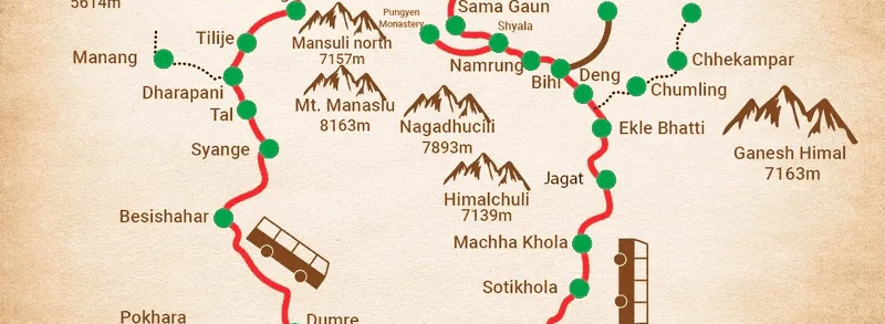
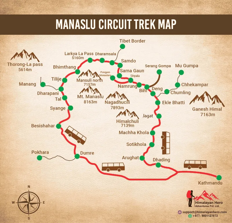
The Manaslu Circuit Trek Map, Explained
Most of the maps floating around online are static images usually licensed from Himalayan Map House or a generic topographic scan showing the trail line, major villages, and rough elevation. They're fine for a general sense of the region but honestly not great for actual day-to-day planning, because they don't tell you where you are relative to your GPS, and a printed map won't reroute you if a bridge has washed out (which does happen here).
How To Actually Read One Of These Maps
A decent Manaslu map should show you four things at minimum:
- The main trekking route with village names and rough elevations
- Side trail junctions (Tsum Valley split, Manaslu Base Camp trail, Rui La viewpoint)
- Checkpoints for permit stamps (Jagat, Deng, Sama Gaon area)
- River crossings and suspension bridges, since these are your main hazard points in the lower valley
If a map you're looking at is missing any of those, it's decorative more than functional.
Why Everyone's GPS Coordinates Are Different
Here's something almost nobody explains properly: different sources cite different altitudes for the same villages because they're pulled from different survey years, different GPS devices, or just copied from an older trekking agency PDF that was never updated. Samagaon gets listed anywhere between 3,520m and 3,530m depending on the source. It's not a huge deal for planning purposes, but it's worth knowing so you're not confused when two of your trekking apps disagree slightly.
Day-By-Day Manaslu Circuit Route Breakdown
This is the part we feel many blogs gloss over with vague descriptions. So, we’ve broken down the Manaslu Circuit route stage by stage based on how we usually see most trekking groups walk it. Your days may shift a little depending on your pace, acclimatization, weather, and trail conditions, but this should give you a much better idea of what we experience along the way.
| Day |
Route |
Approx. Elevation |
Scenery & Highlights |
| Day 1 |
Kathmandu → Machha Khola (drive) |
930 M / 3,051 Ft |
Scenic drive through green hills, terraced farmland, rivers, and mountain valleys as you enter the Manaslu region. |
| Day 2 |
Machha Khola → Jagat |
1,340 M / 4396 Ft |
Walk beside the Budhi Gandaki River through lush forests, rocky cliffs, waterfalls, and traditional hillside settlements. |
| Day 3 |
Jagat → Deng |
1,804 M / 5,918 ft |
Enjoy dramatic river gorges, dense forests, suspension bridges, and increasingly rugged mountain scenery. |
| Day 4 |
Deng → Namrung |
2,630 M / 8,629 ft |
The landscape becomes more alpine, with pine forests, waterfalls, stone villages, and the first impressive Himalayan peaks. |
| Day 5 |
Namrung → Shyala |
3,575 M / 11,730 Ft |
One of the most scenic sections, with panoramic views of Manaslu, Himalchuli, Ganesh Himal, and surrounding snow-covered peaks. |
| Day 6 |
Shyala → Samagaun via Pungyen Monastery |
3,530 M / 11,581 Ft |
Wide mountain valleys, ancient Tibetan-style villages, glacial landscapes, and spectacular views of Manaslu dominate the route. |
| Day 7 |
Acclimatization at Samagaun |
4,800 M / 14,435 ft ( Manaslu Base Camp ) |
Explore the dramatic surroundings with a hike toward Manaslu Base Camp or the turquoise Birendra Lake beneath towering Himalayan peaks. |
| Day 8 |
Samagaun → Samdo |
3,865 M / 12,680 Ft |
The valley opens into a stark high-altitude landscape with yak pastures, barren hills, glaciers, and magnificent mountain views. |
| Day 9 |
Samdo → Dharmashala (Larke Phedi) |
4,460 m (14,632 ft) |
A dramatic alpine landscape of rocky slopes, glacial valleys, and snow-covered peaks surrounds the trail toward Larkya La. |
| Day 10 |
Dharmashala → Larkya La Pass → Bhimthang |
Larkya La Pass: 5,106 m (16,752 ft) Bhimthang: 3,590 m (11,778 ft) |
The highlight of the trek, crossing Larkya La with breathtaking views of glaciers and Himalayan peaks before descending into the beautiful Bhimthang valley. |
| Day 11 |
Bhimthang → Tilije |
2,300 m (7,546 ft) |
Descend through rhododendron and pine forests, with waterfalls, green valleys, and changing mountain landscapes along the way. |
| Day 12 |
Tilije → Dharapani → Besisahar (drive) |
Dharapani: 1,860 m (6,102 ft) Besisahar: 760 m (2,493 ft) |
Enjoy lush forests, waterfalls, terraced hills, and river valleys as the landscape changes from alpine terrain to greener lower valleys. |
| Day 13 |
Besisahar → Kathmandu (drive) |
1,400 m (4,593 ft) |
Scenic journey through Nepal's rolling hills, terraced farmland, rivers, villages, and winding mountain roads. |
| Day 14 |
Final Departure |
1,400 m (4,593 ft) |
Transfer to the airport with your memories of Manaslu's dramatic mountains, remote villages, forests, and high Himalayan landscapes. |
A couple honest notes on this table: some agencies squeeze days 9 and 10 together if the group is acclimatizing well, and some add an extra rest day at Samagaon if anyone's showing symptoms. Don't treat this as gospel, treat it as a solid starting template.
The Larkya La Altitude Confusion (5,106m vs 5,160m)
We said we'd address this. Most official Nepal government and Nepal Tourism Board references list Larkya La at 5,106 meters. A chunk of trekking company websites list it at 5,160m, which seems to trace back to an older survey or possibly just a repeated copy-paste error across the industry. GPS devices carried by guides on recent crossings tend to land closer to the 5,106m figure, so that's the number we'd trust if you need one for planning purposes but don't be shocked if your own device reads a bit differently at the actual pass, GPS altitude readings in the mountains can drift by 20-30 meters depending on satellite coverage.
Side Trips Worth Adding To Your Manaslu Map
The main route is great, but a few detours make the whole trek noticeably better if you have the days.
Manaslu Base Camp
From Samagaon, a day hike takes you up toward Manaslu Base Camp at around 4,800m, with genuinely spectacular close-up views of the mountain. It also doubles as a great acclimatization hike before the pass. Most people who skip this later say they regret it.
Tsum Valley
The Tsum Valley splits off near Lokpa, a bit before Deng, and adds anywhere from 5 to 8 days depending on how deep you go. It's sometimes called the "Hidden Valley" and it genuinely feels that way fewer trekkers even attempt this extension, and the monasteries at Mu Gompa and Rachen Gompa are worth the extra days if your schedule allows it.
Rui La And The Tibet Border
From Samdo, a shorter day hike heads up toward Rui La, close to the Tibetan border, offering wide views back down the valley. It's a good alternative to the base camp hike if you've already done that one, or a solid second acclimatization option.
Permits You'll Need Along This Route
The Manaslu Circuit sits inside a restricted area, which means you can't just show up and walk it solo the way you might in Annapurna. You'll need:
- Manaslu Restricted Area Permit (RAP) required, and you must trek with a licensed guide and in a group of at least two people (this rule does get discussed/revised occasionally, so double check before you go)
- Manaslu Conservation Area Permit (MCAP)
- Annapurna Conservation Area Permit (ACAP) needed because the trail exits through the Annapurna Conservation Area near Dharapani
Permit checks happen at a few points along the route, mainly around Jagat and again near Deng/Namrung, so keep your documents accessible rather than buried at the bottom of your pack (learned that one the hard way once, digging through a duffel bag in the cold while a checkpost officer waited).
The Road-Head Update Nobody's Talking About
Here's something worth flagging that most of the current blogs haven't caught up on: the road being built up the Budhi Gandaki valley from Arughat has been slowly extending further each year. In places, jeep access now reaches closer to Machha Khola or even a bit beyond depending on the season and road conditions, which means some itineraries are quietly shrinking by half a day or more at the start. It's not dramatic yet, but if you're planning a 2026/2027 trip, it's worth asking your operator directly where the actual trailhead will be when you go, rather than assuming it's still Soti Khola. Roads in this part of Nepal also get damaged by monsoon landslides pretty regularly, so "the road reaches X now" can change again within a season.
Safety Notes Tied To The Map
A few specific things worth knowing rather than the generic "be careful of landslides" line you'll see elsewhere:
- The stretch between Machha Khola and Jagat has the most suspension bridge crossings and is where landslide damage after monsoon season tends to show up first
- Larkya La itself is exposed and weather can shift fast most guides push for an early morning start (often before sunrise) specifically to cross before afternoon wind and cloud build-up
- Mobile signal is patchy to nonexistent past Samagaon on most networks, so don't count on calling for help once you're deep into the high section
- The nearest reliable evacuation points by helicopter tend to be Samagaon and, in a pinch, Bimthang on the other side of the pass
Best Time To Trek The Manaslu Circuit
The best time to trek the Manaslu Circuit is spring (March to May) and autumn (late September to November). These months usually bring clearer skies, more stable weather, and better trail conditions, making the high-altitude sections and Larkya La Pass more manageable.
Spring is especially nice if you enjoy flowers, as rhododendrons are in bloom along the lower sections. Winter is possible, but heavy snow can make Larkya La difficult or even temporarily closed. We generally avoid the monsoon months from June to August because of leeches, landslides, muddy trails, and unstable conditions in the lower river valleys.
Wrapping It Up
The Manaslu Circuit is not a trek we recommend doing with just a screenshot of a map and good intentions. Restricted permits, high altitude around Larkya La, changing road conditions, and the remote nature of the route all make a little planning worthwhile. Use this route guide as a starting point, allow enough time for acclimatization, and if your schedule allows, make time for the Manaslu Base Camp side trip.
Still, a map can only tell you so much. The quiet villages, prayer flags moving in the mountain wind, long river valleys, and the views around Samagaon are what make the Manaslu Circuit special.
If you’re planning to trek Manaslu and want help with permits, transportation, guides, and the day-to-day logistics, Himalayan Hero can help you plan the trek around your pace and travel dates.
Frequently Asked Questions
How long is the Manaslu Circuit Trek route in km?
The Manaslu Circuit Trek is roughly 177 km, although the total distance can vary depending on your exact route, side trips, and where you start and finish the trek.
Is there an offline map available for the Manaslu Circuit Trek?
Yes, you can download offline maps using apps such as Maps.me or Gaia GPS before heading into the mountains. We recommend having an offline map because mobile coverage is limited in some sections of the route.
What is the highest point on the Manaslu Circuit Trek map?
The highest point is Larkya La Pass at 5,106 meters (16,752 feet). This is also the toughest section for many trekkers because of the altitude and long walking day.
Can I do the Manaslu Circuit Trek without a guide?
No, the Manaslu region is a restricted trekking area, so you need to trek with a licensed guide and meet Nepal's current permit and group requirements. The exact requirements can change, so it is worth checking before your trek.
Does the Manaslu route connect to the Annapurna Circuit?
Yes, the Manaslu Circuit connects with the Annapurna Circuit around Dharapani. If you have extra time, you can continue toward the Annapurna region rather than ending your trek at Dharapani.
Is there mobile signal along the Manaslu Circuit Trek?
Mobile coverage is available in some lower villages but becomes weak or unavailable in the higher sections, particularly around Samagaon, Samdo, Dharmashala, and Larkya La. We recommend not relying on mobile signal throughout the trek.