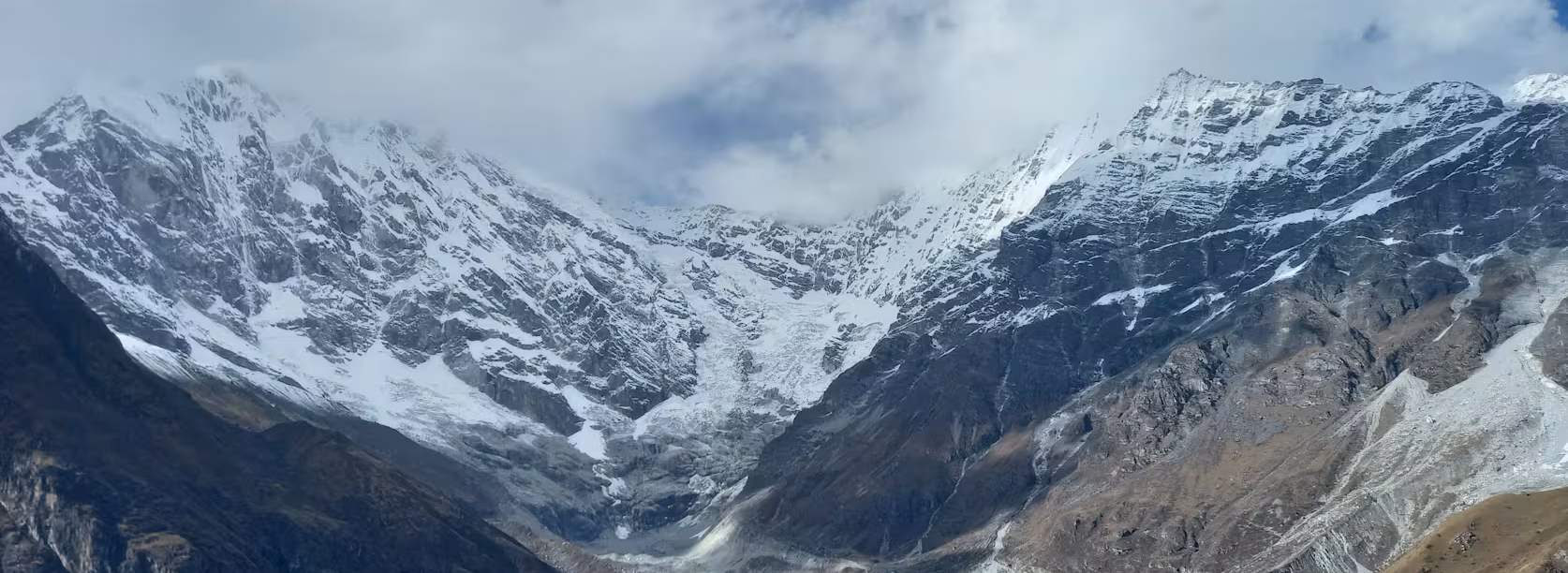
The Langtang Valley Trek distance and elevation are two of the most important things to understand before starting this Himalayan journey. The classic trek covers roughly 65–80 km (40–50 miles) round trip, depending on the starting point and itinerary, while the highest trekking point is usually Kyanjin Ri or Tserko Ri. With steady daily walking and proper acclimatization, it is achievable for many fit beginners and intermediate trekkers.
In this blog, you’ll learn how far the Langtang Valley Trek is, how high you’ll climb, what the elevation gain feels like, and how distance and altitude affect difficulty. You’ll also get practical insight into the itinerary, walking conditions, best seasons, costs, beginner suitability, and the valley’s recovery since the 2015 earthquake.
Langtang Valley Trek Distance and Elevation at a Glance
The Langtang Valley Trek covers approximately 65–80 km (40–50 miles) round trip, depending on your itinerary, road access, and whether you include side trips. The trek starts at Syabrubesi at around 1,550 m (5,085 ft) and reaches Kyanjin Gompa at about 3,870 m (12,697 ft) as the highest standard overnight point. Trekkers who add Kyanjin Ri or Tserko Ri can climb significantly higher, reaching roughly 4,773 m or 4,984 m respectively.
The exact distance is not the same for every trekker. A straightforward Langtang Valley itinerary without major side trips is shorter, while adding viewpoints, acclimatization walks, and exploration around Kyanjin Gompa increases both walking distance and elevation gain. For this reason, it is useful to distinguish between your highest overnight elevation and the highest point you reach during the entire trek.
How High Is the Langtang Valley Trek?
The elevation rises steadily as you move from the lower hills toward the alpine Langtang Valley. You begin at Syabrubesi (1,550 m) and pass through forested sections before reaching Lama Hotel, Langtang Village, and finally Kyanjin Gompa.
| Trekking Point |
Approx. Elevation |
| Syabrubesi |
1,550 m (5,085 ft) |
| Lama Hotel |
2,380 m (7,808 ft) |
| Langtang Village |
3,430 m (11,253 ft) |
| Kyanjin Gompa |
3,870 m (12,697 ft) |
| Kyanjin Ri |
4,773 m (15,659 ft) |
| Tserko Ri |
4,984 m (16,352 ft) |
Kyanjin Gompa is generally the highest overnight point on the standard Langtang Valley Trek. However, it is not necessarily the highest elevation you will reach. If you hike to Kyanjin Ri or Tserko Ri, you can gain another 900–1,100 m above the village.
This distinction matters when preparing for altitude. You may sleep at 3,870 m but temporarily climb close to 5,000 m during a day hike before returning to Kyanjin Gompa.
How Far Do You Walk on the Langtang Valley Trek?
The total walking distance varies according to your route and side trips. A typical itinerary involves several days of moderate-distance walking, with the return generally following the same valley route.
| Section |
Approx. distance |
Typical walking time |
| Syabrubesi → Lama Hotel |
6–7 km |
5–6 hrs |
| Lama Hotel → Langtang Village |
6–7 km |
5–6 hrs |
| Langtang Village → Kyanjin Gompa |
6 km |
3–4 hrs |
| Kyanjin exploration |
Variable |
3–7 hrs |
| Return journey |
Similar route |
5–6 hrs/day |
These figures are useful estimates rather than fixed measurements. Trail conditions, your walking pace, rest stops, accommodation location, and optional climbs can all change the actual distance covered in a day.
The Kyanjin exploration day is usually where the distance and elevation can increase considerably. A short walk around the village is relatively easy, while climbing Tserko Ri involves a much steeper and more demanding day.
How Quickly Does the Trek Gain Elevation?
Elevation gain is often more important than distance when judging how difficult a trekking day will feel. The Langtang route climbs from 1,550 m at Syabrubesi to around 3,870 m at Kyanjin Gompa, with the biggest challenge coming from the combination of uphill walking and increasingly thin air
| Point |
Approx. elevation |
Elevation change |
| Syabrubesi |
1,550 m |
Starting point |
| Lama Hotel |
2,380 m |
+830 m |
| Langtang Village |
3,430 m |
+1,050 m |
| Kyanjin Gompa |
3,870 m |
+440 m |
| Kyanjin Ri |
4,773 m |
+903 m from Kyanjin |
| Tserko Ri |
4,984 m |
+1,114 m from Kyanjin |
The numbers show why a relatively short walking day can still be demanding. Once you climb above 3,000 m, your body has less available oxygen, and steep ascents require more effort. A 6 km uphill day at high altitude can feel substantially harder than a longer walk on relatively flat ground at low elevation.
Interesting fact: The Langtang route passes through several distinct landscapes in a relatively short trek, from lower-elevation forests to an alpine environment around Kyanjin Gompa.
How Long Does the Langtang Valley Trek Take?
Most trekkers should allow around 7–10 days for a comfortable Langtang Valley Trek itinerary, depending on transportation, acclimatization, walking pace, side trips, and how much time you want to spend around Kyanjin Gompa. A shorter 5–6-day schedule is possible for experienced hikers, but adding a few extra days gives you more flexibility for altitude, weather, rest, and exploration.
How Many Days Do You Need for Langtang Valley?
There is no single perfect number of days for the Langtang Valley Trek. Your fitness, available time, transportation conditions, and interest in side hikes all affect the ideal itinerary.
| Trek style |
Approx. duration |
Suitable for |
| Fast |
5–6 days |
Experienced trekkers with limited time |
| Standard |
7–8 days |
Most trekkers |
| Relaxed |
9–10+ days |
Slow pace and extra exploration |
A 5–6-day itinerary can work if you are fit, accustomed to long walking days, and comfortable keeping the schedule tight. However, rushing means less time to adjust to increasing elevation and less flexibility if you feel tired or the weather changes.
For most people, 7–8 days is a better balance. You can walk at a reasonable pace, spend time at Kyanjin Gompa, and include a viewpoint hike without making every day feel like a race.
A 9–10-day itinerary is useful if you prefer slower walking, photography, cultural experiences, or additional time around Kyanjin Gompa. It can also make the trek feel less physically demanding because you have more time to manage your daily pace.
How Long Do You Walk Each Day?
On a typical Langtang Valley Trek, expect around 4–7 hours of walking per day, although some days can be shorter or longer. The actual experience depends on the distance, elevation gain, trail conditions, weather, and your walking speed.
Several factors affect how long a trekking day takes:
- Walking distance: A 6 km day does not necessarily take the same time as another 6 km day.
- Elevation gain: Steep uphill sections slow you down, particularly above 3,000 m.
- Terrain: Stone steps, rocky paths, forest trails, and uneven sections require different walking speeds.
- Breaks: Tea houses provide convenient places to stop for tea, lunch, water, or rest.
- Photography: Langtang has frequent viewpoints, so stopping for photographs naturally adds time.
- Weather: Rain, snow, fog, or strong winds can slow progress.
- Personal pace: A strong hiker may finish a section considerably faster than someone taking a relaxed pace.
An itinerary that says “5 hours walking” does not mean five hours of continuous walking. In practice, you may spend additional time taking breaks, eating lunch, photographing the mountains, talking with locals, or waiting for other members of your group.
Your actual itinerary can also differ because road conditions and transportation arrangements change, particularly on the journey between Kathmandu and Syabrubesi. Road delays, seasonal conditions, or changes in local transport can affect when you reach the trailhead and how the trekking days are arranged.
Why I Would Not Rush the Kyanjin Gompa Day
I would not treat reaching Kyanjin Gompa as simply the finish line. It is one of the best places on the trek to slow down and actually experience the valley.
From Kyanjin Gompa, you have time to appreciate the surrounding Himalayan scenery, explore the village, take photographs, and choose a side hike such as Kyanjin Ri or Tserko Ri if conditions and fitness allow.
Allowing enough time here also gives you something that a rushed itinerary cannot provide: flexibility. If the weather is cloudy one afternoon, you may have another morning for mountain views. If your legs are tired after the climb to Kyanjin, you can recover before attempting a higher viewpoint.
For me, the value of the Langtang trek is not just how quickly you reach Kyanjin Gompa. It is the gradual change from forested lower valleys to the dramatic alpine landscape around the village. Giving yourself time to experience that transition makes the trek far more rewarding than simply trying to complete it in the fewest possible days.
How Difficult Is the Langtang Valley Trek?
The Langtang Valley Trek is a moderate Himalayan trek and is achievable for many beginners, but altitude and repeated uphill walking should not be underestimated. You do not need technical climbing skills, but you should be prepared to walk for several hours a day on uneven trails while gradually gaining elevation. Good preparation, sensible pacing, and proper acclimatization are more important than previous Himalayan trekking experience.
Is Langtang Trek Suitable for Beginners?
Yes, Langtang is suitable for many beginners who have reasonable fitness and prepare properly. The route does not involve technical climbing, ropes, or mountaineering skills on the standard trekking itinerary.
Previous trekking experience can certainly help, but it is not mandatory. A first-time Himalayan trekker can complete the route if they are comfortable with several hours of walking and prepare their legs and cardiovascular system beforehand.
What matters most is being prepared for:
- Regular uphill walking rather than technical climbing
- Several hours on your feet each trekking day
- Uneven trails, rocks, and stone steps
- Increasing altitude as you approach Kyanjin Gompa
- Slower walking at higher elevations
- Cold conditions, particularly around Kyanjin
- Taking rest and acclimatization seriously
A few weeks of regular walking, hiking, stair climbing, or cardiovascular exercise before the trek can make a noticeable difference. You do not need to be an elite athlete. Consistent preparation matters more than having previous Himalayan experience.
What Makes Langtang Valley Trek Difficult?
The langtang difficulty comes mainly from altitude, elevation gain, and the number of hours spent walking, rather than from technical terrain.
- Increasing altitude: The trail rises from around 1,550 m at Syabrubesi to approximately 3,870 m at Kyanjin Gompa.
- Long uphill sections: Some days involve sustained climbs that can be tiring even when the total distance looks modest.
- Uneven terrain: Rocky paths and irregular sections require careful footing.
- Stone steps: Sections of the route include repeated stone steps, which can put extra strain on your legs.
- Several hours of walking: Most trekking days involve around 4–7 hours of movement, depending on the itinerary and pace.
- Cold conditions: Temperatures drop as you gain elevation, especially around Kyanjin Gompa and during early-morning hikes.
- Weather changes: Mountain weather can change quickly and may affect walking conditions and visibility.
- Limited facilities: Accommodation, food choices, and other services become more basic as you move higher into the valley.
The important point is that distance alone does not determine difficulty. A relatively short uphill section at 3,500 m can feel considerably harder than a longer walk at lower elevation.
Expert opinion: I would not market Langtang as an “easy trek.” Calling it moderate gives beginners a much more realistic expectation. You do not need to be an experienced mountaineer, but you should arrive prepared for sustained uphill walking and the effects of altitude.
What Is the Highest Point of the Langtang Valley Trek?
The highest point depends on how you plan your trek. Kyanjin Gompa is the main destination and highest standard overnight settlement, at about 3,870 m (12,697 ft). Trekkers who want to go higher can take optional day hikes to viewpoints such as Kyanjin Ri or Tserko Ri. These climbs can take the maximum elevation of the trek to roughly 4,600–5,000 m, depending on the route and the exact summit point.
Kyanjin Gompa vs Kyanjin Ri vs Tserko Ri
It is useful to separate the main trekking destination from the optional viewpoints. Elevation figures can vary between maps, route descriptions, and summit markers, so final figures should be checked against current local or official sources before publication.
| Point |
Approx. elevation |
What it is |
| Langtang Village |
~3,430 m |
Major overnight settlement |
| Kyanjin Gompa |
~3,870 m |
Main trek destination |
| Kyanjin Ri |
~4,600 m+ |
Optional viewpoint |
| Tserko Ri |
~4,900 m+ |
Higher and more demanding viewpoint |
Kyanjin Gompa is where most standard Langtang itineraries finish their ascent. You can spend the night here and use the following day to explore the surrounding valley or attempt a higher viewpoint.
Kyanjin Ri provides a significant elevation gain above the gompa and is popular for panoramic mountain views. Tserko Ri is higher and generally more demanding, requiring greater physical effort and stronger acclimatization.
This is why saying that the Langtang Valley Trek simply reaches “4,900 m” can be misleading. Most trekkers do not sleep at that elevation. Your highest point depends on whether you choose to add one of these optional climbs.
Do You Need to Climb Tserko Ri?
No, Tserko Ri is completely optional. You can have a rewarding Langtang Valley Trek without climbing it. Reaching Kyanjin Gompa itself provides an impressive high-altitude Himalayan experience, with opportunities to explore the village and surrounding valley.
If you are considering Tserko Ri, remember that the climb adds considerable physical effort:
- It requires substantial uphill walking from Kyanjin Gompa.
- An early start may be necessary to take advantage of better morning conditions.
- Weather can make a major difference to visibility, temperature, and trail conditions.
- Altitude makes the climb harder than the distance alone suggests.
- Your acclimatization matters more than simply being able to walk long distances at low elevation.
For a well-acclimatized and physically prepared trekker, Tserko Ri can be a rewarding objective. If you are feeling unusually tired, experiencing altitude-related symptoms, or facing poor weather, there is no reason to treat the summit as compulsory.
My recommendation is simple: treat Tserko Ri as a bonus, not a requirement. The best choice is the one that fits your fitness, acclimatization, weather conditions, and overall condition on the day.
What Happens to Your Body as You Gain Elevation?
As you climb higher, the amount of oxygen available to your body decreases. Your body has to work harder during physical activity, which is why a familiar uphill walk can suddenly feel much more difficult at higher elevations.
Some people may experience symptoms such as:
- Headache
- Unusual tiredness or fatigue
- Shortness of breath during exertion
- Reduced appetite
- Changes in sleep
- Feeling generally unwell
Mild symptoms can occur as your body adjusts, but they should not simply be ignored or pushed through. Symptoms that become severe, worsen, or affect your ability to walk normally require immediate attention. Descending to a lower elevation is an important response to serious altitude-related illness, and trekkers should follow the advice of their guide or medical professionals.
The safest approach is to ascend gradually, maintain a sensible pace, stay hydrated, eat regularly, and allow time for acclimatization. Do not judge your ability to handle altitude solely by how fit you are at sea level. Even very fit hikers can experience altitude problems.
Langtang Valley Trek Altitude Profile
The Langtang Valley Trek altitude profile shows a steady climb from Syabrubesi at around 1,550 m to Kyanjin Gompa at approximately 3,870 m. The route gains elevation through forested valleys, alpine settlements, and increasingly open mountain terrain. If you add Kyanjin Ri or Tserko Ri, the trail climbs above 4,600 m and can approach 4,900 m.
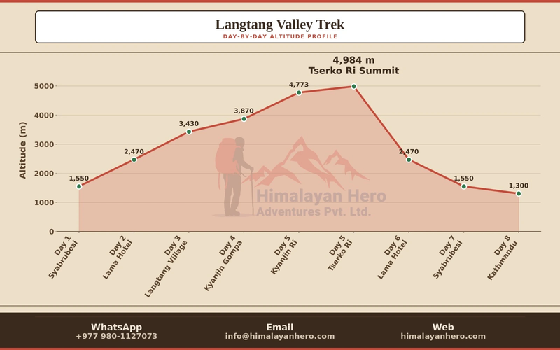
The profile is useful because it shows how quickly elevation changes, not just the highest point. The climb is spread across several days, with the biggest change occurring as you move from Lama Hotel through Langtang Village toward Kyanjin Gompa.
| Trek Point |
Approx. Elevation |
| Syabrubesi |
1,550 m |
| Lama Hotel |
2,470 m |
| Langtang Village |
3,430 m |
| Kyanjin Gompa |
3,870 m |
| Kyanjin Ri |
4,600 m+ |
| Tserko Ri |
4,900 m+ |
From Syabrubesi to Lama Hotel, the trail climbs through forest and follows the river valley. The elevation gain is noticeable, but the surrounding vegetation and relatively lower altitude make this section feel quite different from the upper valley.
The next major change comes between Lama Hotel and Langtang Village, where the trail rises to around 3,430 m. By this point, altitude starts becoming a more important part of the trekking experience. Walking pace often becomes slower, particularly on sustained uphill sections.
From Langtang Village to Kyanjin Gompa, the distance is comparatively short, but you continue climbing toward 3,870 m. The landscape also changes dramatically. Forest becomes sparser, the valley opens up, and the surrounding mountains become much more prominent.
From Kyanjin Gompa, trekkers can choose to climb higher. Kyanjin Ri provides an optional viewpoint above 4,600 m, while Tserko Ri takes the climb close to 4,900 m. These side trips are considerably more demanding because they combine steep uphill terrain with high altitude.
The key thing to understand from the altitude profile is that the highest elevation is not the only factor that determines difficulty. The rate of ascent, overnight elevation, daily elevation gain, individual acclimatization, and whether you add a high viewpoint all affect how the trek feels.
For most trekkers, the section around Langtang Village and Kyanjin Gompa is where altitude becomes much more noticeable. This is why maintaining a comfortable pace and allowing enough time for the ascent is more important than trying to complete each day's walk as quickly as possible.
Interesting fact: One of the reasons Langtang is such a rewarding short Himalayan trek is the dramatic change in landscape over this elevation profile, from lower forested terrain near Syabrubesi to the high alpine surroundings of Kyanjin Gompa.
Plan Your Langtang Valley Trek
Now that you understand the Langtang Valley Trek distance, elevation, and altitude profile, you can plan your days around the actual trail rather than simply counting kilometers. Give yourself enough time to adjust to the altitude, choose side trips that match your fitness, and leave some room to enjoy Kyanjin Gompa and the surrounding mountains.
If Langtang feels like the right trek for you, take a look at our Langtang Valley Trek itinerary to see the daily route, inclusions, and practical details before deciding on your trip.
Explore More Langtang Treks
If you are still deciding which Langtang route suits your time, interests, and trekking experience, you may also want to explore these alternatives:
- Ganesh Himal Trek – a quieter route with mountain scenery, villages, and fewer trekkers.
- Langtang Helambu Trek – a great option if you want to combine Langtang with the culturally rich Helambu region.
- Langtang Gosaikunda Trek – ideal if you want to combine the Langtang Valley with the sacred Gosaikunda lakes.
Take a look at the routes above and compare their distance, elevation, duration, and overall trekking experience before choosing the one that fits your plans.