The trails around Mount Manaslu carried salt traders between Nepal and Tibet for centuries before anyone thought of trekking permits. When Nepal finally opened the region to foreign visitors in 1991, it lifted restrictions that had kept one of the Himalaya's most culturally preserved corridors hidden from the outside world.
This guide traces the Manaslu Circuit Trek journey from ancient trade route to restricted border zone to one of Nepal's most sought-after treks, covering the key dates, the forces that shaped the region, and why its history still matters for anyone planning to walk the circuit today.
What Is the Manaslu Circuit Trek
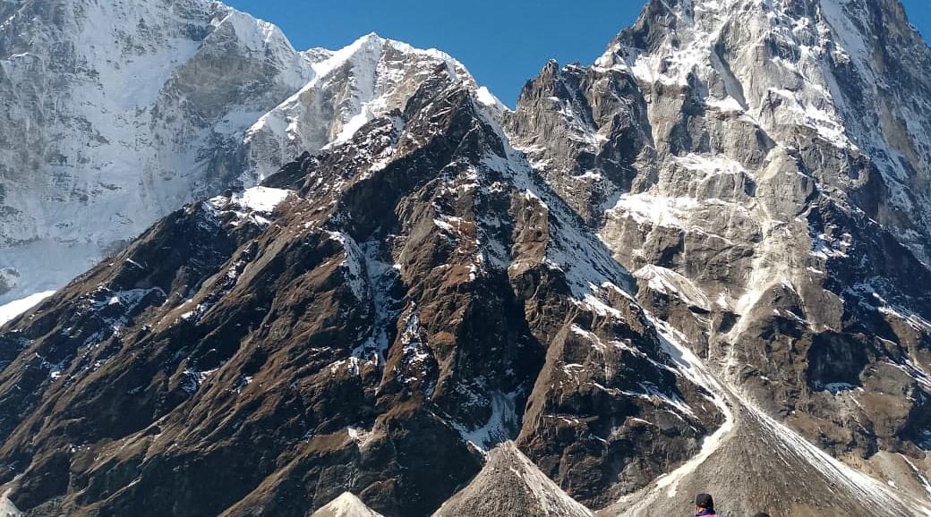
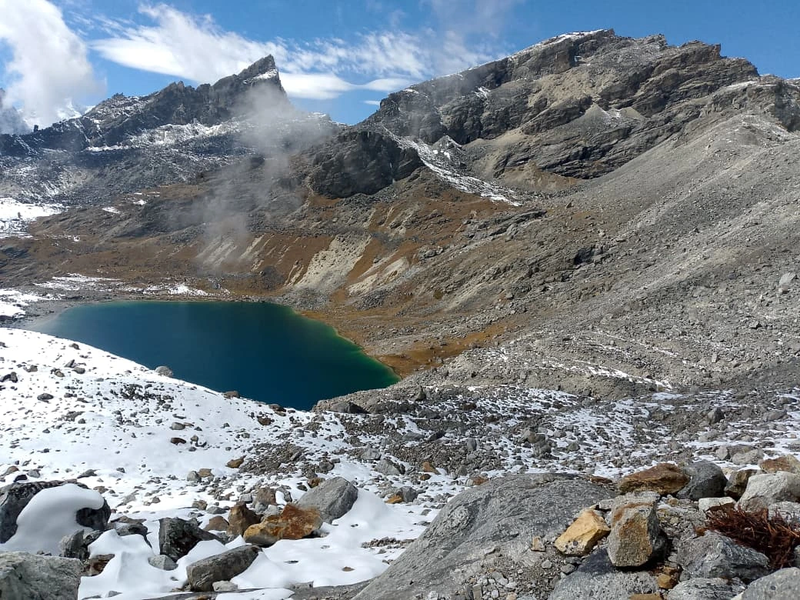
The Manaslu Circuit Trek is a multi-day route that circles Mount Manaslu, the world's eighth-highest peak at 8,163 meters, and crosses Larkya La Pass at 5,160 meters. Nepal officially opened the region to foreign trekkers in 1991, ending decades of restrictions tied to its location near the Tibet-China border. The trek remains a restricted area today, meaning all trekkers require special permits and a licensed guide.
- Location: Gorkha District, north-central Nepal
- Highest Point: Larkya La Pass at 5,160 metres
- Trek Duration: Typically 12–18 days
- Trek Style: Teahouse trekking with mandatory licensed guide
The restricted status has preserved something increasingly rare in Himalayan trekking: authentic village life, centuries-old cultural highlights of the Manaslu Circuit, and trails that feel genuinely remote. While the Everest Base Camp and Annapurna regions see tens of thousands of trekkers annually, the Manaslu Circuit maintains a quieter character.
Ancient Trade Routes That Shaped the Manaslu Region
Long before anyone thought of trekking permits or teahouse lodges, the trails around Manaslu served a practical purpose: trade. For centuries, these paths were lifelines, connecting isolated mountain communities that would otherwise have been cut off from the world. The routes crossed one of the most formidable mountain barriers on Earth, linking Nepal's lower valleys with the high Tibetan plateau. Salt moved south, grain traveled north, and generations of traders carved paths through terrain that would challenge even modern trekkers.
These weren't recreational trails. They were economic arteries that sustained entire communities. Yak caravans navigated narrow cliff paths, crossed raging rivers, and climbed steep mountain passes because survival depended on it. The trade routes had to remain passable regardless of weather, season, or difficulty. What you walk today as a trekker follows the same fundamental corridors that traders used for centuries, maintained not for tourism but for the movement of goods that kept high Himalayan villages alive. The trails were engineered through necessity, refined through generations of use, and built to last.
Nepal-Tibet Salt and Grain Trading Heritage
For centuries, traders moved salt south from Tibet and carried grain north from Nepal's lower valleys through the Budhi Gandaki corridor, the same river valley that today's trekkers follow. Salt was precious in the lower valleys where it couldn't be produced, while grain grew abundantly in Nepal's middle hills but couldn't survive at high altitudes. This complementary exchange created a trading system that sustained communities on both sides of the Himalayan divide. Generations of traders and their yak caravans carved and maintained the trails, creating the basic route structure the modern circuit still uses.
The salt-grain trade formed the economic backbone of high Himalayan communities. Villages like Samagaun and Samdo existed primarily because they sat along these trading corridors, serving as rest stops, trading posts, and seasonal markets. The paths had to be passable even in difficult conditions. Traders couldn't afford to wait weeks for snow to clear or rivers to subside. So you're walking on routes engineered for survival rather than tourism, built to standards dictated by economic necessity rather than recreational comfort. The trail's character today (its directness, its pragmatic approach to obstacles, its refusal to take the easy route) reflects this heritage.
Gurung and Tibetan Settlements Along the Circuit
The lower sections of the circuit pass through Gurung villages, communities with their own distinct language, traditions, and agricultural practices. Gurung culture dominates the southern approach, with terraced fields, stone houses, and a way of life shaped by generations of farming and animal husbandry. As you gain elevation, the cultural landscape shifts toward Tibetan Buddhist influence, particularly in upper villages like Samagaun and Samdo. The transition isn't abrupt but gradual, a reflection of centuries of cultural exchange along the trading routes. Architecture changes, religious practices shift, and even the language you hear in teahouses transforms as you climb higher into the mountains.
Samagaun, for instance, has been a trading hub and religious center for centuries. The monasteries there still function as active spiritual communities rather than tourist attractions, with monks maintaining daily practices that predate any foreign visitor's arrival. The village's position along the trade route made it prosperous enough to support religious institutions, and those monasteries in turn attracted pilgrims and traders seeking blessings before crossing the high passes. This cultural layering (Gurung foundations with Tibetan Buddhist overlay, shaped by centuries of trade) creates the distinctive character that makes the Manaslu Circuit culturally richer than many purely scenic treks.
Origin of the Name Spirit Mountain
The name "Manaslu" derives from the Sanskrit word manasa, meaning spirit or soul. Local communities have long regarded the peak with reverence. It's not simply a geographical feature but a sacred presence in the landscape. Mountains in Himalayan culture aren't just obstacles to cross or summits to climb; they're dwelling places of deities, sources of life-giving water, and spiritual anchors that define the relationship between people and place. Manaslu holds this sacred status for the communities that live in its shadow, shaping religious practices, seasonal rhythms, and cultural identity in ways that outsiders often miss.
This spiritual dimension predates mountaineering by centuries. Long before anyone measured Manaslu's height or attempted its summit, local communities incorporated the mountain into their cosmology and daily life. Prayer flags flutter on high passes not as decoration but as offerings. Monasteries face the peak deliberately. Seasonal festivals align with the mountain's moods: the arrival of monsoon clouds, the first winter snows, and the spring melt that brings water to the fields. Understanding this spiritual context adds depth to the trek, transforming what could be merely a physical challenge into a journey through a landscape where every ridge, pass, and river carries cultural meaning.
Why the Manaslu Region Was Restricted to Foreigners
The Manaslu region was restricted to foreigners because of its proximity to the Tibet-China border. Following Nepal's opening to foreign visitors in the 1950s, the government maintained strict controls on who could enter this politically sensitive border area for decades. The northern sections of the circuit run parallel to the Tibetan border, close enough that unrestricted foreign access raised security concerns. While Nepal welcomed tourism and recognized its economic potential, the government wasn't willing to compromise border security for trekking revenue. The Manaslu region remained firmly closed while other areas opened to foreign visitors.
Security concerns drove the policy. The border area was politically sensitive, and allowing unrestricted foreign access wasn't considered viable. While trekkers explored Everest and Annapurna freely, the Manaslu trails remained off-limits, used only by local communities and the occasional mountaineering expedition with special government permission. The long closure, though frustrating for early adventure travelers, inadvertently preserved the region's character in ways that more accessible areas lost. Villages didn't develop tourist infrastructure, trails weren't widened or "improved" for foreign visitors, and local culture evolved without the influence of mass tourism. What seemed like a barrier at the time became, in retrospect, a form of protection that maintained authenticity other regions couldn't preserve.
When Nepal Opened the Manaslu Circuit for Trekking
In 1991, Nepal officially opened the Manaslu region to foreign trekkers. The decision balanced two competing interests: generating tourism revenue from an increasingly popular industry while maintaining oversight of a sensitive border zone. By the early 1990s, trekking had become a significant part of Nepal's economy, and the government recognized that keeping the Manaslu region completely closed meant forfeiting substantial potential income. The solution was controlled access: opening the region but maintaining restrictions that would limit numbers and ensure government oversight of who entered the border area.
The opening came with significant restrictions. Initial permit fees were high, and trekkers were required to travel in groups with minimum numbers, a requirement that still applies today under Nepal's current trekking permit regulations. The Annapurna Circuit had been open to trekkers for years before Manaslu's restrictions lifted, which partly explains why Manaslu remained less developed and less crowded. This timing difference fundamentally shaped each trek's character. While Annapurna developed extensive infrastructure and became one of Nepal's busiest routes, Manaslu's late opening preserved its remote atmosphere and authentic village culture. Today, the comparison between Manaslu and Annapurna reveals two distinct experiences: Annapurna offers well-established facilities and diverse landscapes, while Manaslu delivers genuine remoteness and fewer trekkers on the trail, a direct result of their different historical trajectories.
Early Challenges After the Region Opened
The first trekkers to explore the Manaslu Circuit encountered conditions far removed from today's experience. This was expedition-style travel in every sense: remote, unpredictable, and requiring genuine self-sufficiency. Villages had no infrastructure for foreign visitors. The trails themselves were maintained only to the standard needed for local trade, not recreational trekking. There were no lodges, no menus in English, no established systems for accommodating foreigners who didn't speak Nepali or Tibetan. Early trekkers needed to be genuinely self-reliant, carrying everything they needed and prepared to solve problems without external support.
The challenges went beyond simple discomfort. Navigation was difficult without clear trails or signage. River crossings could be genuinely dangerous, especially during monsoon season when water levels rose. Medical emergencies had no evacuation protocols. If something went wrong, you were days of difficult walking from any road, let alone proper medical care. The trekkers who came in those early years were experienced mountaineers and adventurers who understood the risks and accepted them as part of the experience. Their willingness to endure harsh conditions opened the route for others, proving that the circuit was viable for tourism even if it demanded more from trekkers than Nepal's established routes.
Difficult Trails and Limited Facilities
Trail infrastructure barely existed. River crossings relied on precarious log that shifted with seasonal floods; paths were unmarked and often unclear where they diverged from local routes, and English-speaking locals were rare outside of the few who had worked with mountaineering expeditions. There were no signposts indicating distances or directions, no emergency protocols if someone got injured or sick, and no reliable communication with the outside world. Trekkers navigated by asking locals, following the most worn paths, and hoping they were heading in the right direction. Getting lost wasn't just possible. It was common.
The villages themselves offered minimal support. Most families had never hosted foreign visitors and had no facilities for doing so. Trekkers might find a family willing to provide a meal or a place to sleep on a kitchen floor, but this was hospitality extended to strangers rather than a commercial transaction. There were no menus, no set prices, and no established expectations about what services would be provided. Communication happened through gestures and the few Nepali words trekkers might have learned. The experience was culturally immersive by necessity rather than design. You couldn't maintain tourist distance when you were sleeping in someone's home and eating whatever they prepared for their own family.
Camping Requirements Before Teahouses
Teahouse trekking (the lodge-to-lodge style that defines most Nepal treks today) simply wasn't an option in the early years. All trekkers needed full camping equipment: tents, cooking gear, food supplies for the entire journey, and support staff to carry and manage everything. The logistics made the Manaslu Circuit trek cost expensive and accessible only to well-organized groups with substantial budgets. You couldn't just show up with a backpack and start walking. The trek required expedition-level planning and resources.
This camping requirement fundamentally limited who could attempt the circuit. Independent travelers and budget trekkers who might tackle Annapurna or Everest Base Camp on their own couldn't afford the Manaslu Circuit. The need for porters, cooks, guides, and full camping equipment meant only organized groups with significant financial backing could attempt the route. This kept numbers low but also meant the trek remained the domain of serious mountaineers and adventure travelers rather than becoming accessible to the broader trekking community. The eventual development of teahouses would democratize access, but in those early years, the Manaslu Circuit was genuinely exclusive, not by regulation but by practical necessity.
First Foreign Trekking Groups
The early trekkers who accepted harsh conditions were a self-selecting group: experienced adventurers willing to trade comfort for authenticity. These weren't casual tourists looking for a Himalayan experience with hot showers and comfortable beds. They were mountaineers, explorers, and serious trekkers who valued remoteness and cultural immersion over convenience. Their accounts and photographs helped establish the Manaslu Circuit's reputation as one of Nepal's most rewarding and most demanding treks. The stories they brought back emphasized both the difficulty and the extraordinary cultural and scenic rewards of the route.
These pioneering groups played a crucial role in the circuit's development. Their feedback helped local communities understand what foreign trekkers needed and valued. Their willingness to pay for services (even basic ones like meals and shelter) demonstrated that tourism could provide economic opportunities. And their accounts in trekking magazines and guidebooks spread word about the circuit to the broader adventure travel community. Without these early adopters willing to endure expedition conditions, the Manaslu Circuit might have remained closed or developed much more slowly. They proved the route's viability and created the foundation for the teahouse infrastructure that would eventually make the trek accessible to a wider range of trekkers.
How the Manaslu Conservation Area Was Established
In 1998, Nepal designated the region as the Manaslu Conservation Area, placing it under the management of the National Trust for Nature Conservation (NTNC). The conservation area addressed both ecological and cultural preservation, recognizing that the region's value extended beyond its trekking potential. The designation came seven years after the region opened to trekkers, enough time for the government to recognize that tourism was growing and that without formal protection, the area's environmental and cultural resources could be degraded. The conservation framework aimed to ensure that tourism development happened sustainably rather than exploitatively.
The region harbors 33 mammal and 110 bird species, including snow leopards, Himalayan tahr, and red pandas. The biodiversity alone justified protection, but equally important, the conservation framework aimed to protect the Gurung and Tibetan Buddhist cultural heritage that makes the trek distinctive. The NTNC model emphasizes community involvement. Local people participate in management decisions and benefit economically from conservation efforts. This approach recognizes that preservation only works when local communities see tangible benefits rather than just restrictions. The conservation area framework created mechanisms for channelling tourism revenue into community development, environmental protection, and cultural preservation, establishing a model that balanced multiple interests rather than prioritizing any single goal.
How Teahouses and Trail Infrastructure Developed
The transformation from expedition camping to teahouse trekking happened gradually over roughly two decades, fundamentally changing who could access the area. What began as an expedition requiring full camping gear, porters, and significant financial resources evolved into a more accessible lodge-based trek. This shift opened the Manaslu Circuit to independent travelers and smaller groups who previously couldn't have afforded the logistics of a fully supported camping expedition. The change wasn't planned by any central authority. It emerged organically as local families recognized economic opportunities and began building infrastructure to serve foreign visitors.
The development followed a pattern seen in other Himalayan regions but happened later and more slowly on the Manaslu Circuit. Early lodges were extremely basic, often just a room in a family home where trekkers could sleep on the floor. Over time, as more trekkers arrived and competition increased, facilities improved. Families built dedicated guesthouses with separate rooms, dining areas, and basic amenities. The pace of development varied by location. Lower villages closer to road access developed faster, while upper villages remained more basic. This gradual evolution meant the circuit never experienced the rapid, sometimes chaotic development that transformed other trekking regions, preserving a more authentic character even as infrastructure improved.
Transition from Camping to Lodge Trekking
Local families began building simple lodges in the late 1990s and early 2000s, recognizing the economic opportunity that trekking tourism represented. Early lodges were basic, often just a room in a family home with a shared sleeping area and meals prepared in the family kitchen. There were no private rooms, no separate dining areas, and certainly no amenities like hot showers or electricity. But they offered something crucial: an alternative to carrying full camping equipment. Trekkers could travel lighter, move faster, and reduce costs by staying in these basic lodges rather than bringing tents and hiring full support staff.
Over time, dedicated guesthouses emerged with private rooms, dining areas, and increasingly reliable meal service. Families who invested in better facilities attracted more trekkers, creating competitive pressure that drove improvements across the circuit. The shift democratized access. Trekkers no longer needed expedition budgets or extensive camping experience, making the Manaslu Circuit Trek accessible for beginners with proper preparation. This transformation opened the trek to a much broader demographic: younger travelers, budget-conscious adventurers, and people who wanted the Himalayan experience without the complexity and expense of expedition-style trekking. The circuit's character changed, but it remained more remote and less developed than Nepal's busiest routes.
Bridge and Trail Improvements
Government and NGO investment gradually replaced the most dangerous river crossings with suspension bridges. The Budhi Gandaki valley experiences dramatic seasonal variation in water levels, and the old log bridges that served local traders became genuinely hazardous during monsoon season. Suspension bridges, funded through a combination of government infrastructure programs and conservation area budgets, made crossings safer and more reliable year-round. Trail maintenance programs improved path conditions and added basic signage, making navigation easier for trekkers unfamiliar with the region.
The route became safer and more navigable, though it retained its remote character. The improvements focused on genuine safety issues rather than making the trek easy or comfortable. Trails remained steep, rocky, and physically demanding. The infrastructure upgrades simply reduced the risk of serious accidents from bridge failures or getting lost in unmarked terrain. This balanced approach preserved the trek's adventurous character while making it accessible to trekkers who weren't willing to accept the expedition-level risks of the early years. The circuit remained challenging but became less dangerous, an important distinction that allowed it to attract more visitors without losing its essential character.
Communication and Safety Upgrades
Satellite phones arrived first, providing emergency communication capability for guides and lodge owners. Before satellite technology, a serious medical emergency meant days of evacuation on foot with no way to call for help or coordinate rescue efforts. Satellite phones changed this fundamentally. Guides could contact rescue services, coordinate helicopter evacuations, and communicate with trekking agencies in Kathmandu. Limited mobile coverage eventually reached some villages, though connectivity remains unreliable in many sections. The coverage is patchy and weather-dependent, but it represents a significant safety improvement over a complete communication blackout.
Helicopter evacuation protocols developed alongside the broader growth of Nepal's trekking industry. Insurance companies established relationships with helicopter operators, creating systems for emergency evacuations that didn't exist in the early years. Lodges learned to maintain helicopter landing zones, guides received training in emergency protocols, and the entire system became more professionalized. These safety upgrades didn't eliminate risk. The Manaslu Circuit remains a high-altitude trek through remote terrain where weather can change rapidly and altitude sickness remains a serious concern. But they created safety nets that make the trek viable for people who wouldn't have attempted it under the expedition conditions of the 1990s.
Growth as an Alternative to Everest and Annapurna
By the mid-2000s, tourism boards and trekking operators began actively promoting the Manaslu Circuit as an alternative to Nepal's increasingly crowded flagship treks. The pitch was straightforward: similar Himalayan grandeur, genuine cultural immersion, and far fewer people on the trail. Everest Base Camp and the Annapurna Circuit had become victims of their own success, so popular that the experience was degraded by crowds, commercialization, and the infrastructure needed to support tens of thousands of annual visitors. Trekkers who wanted authentic Himalayan experiences without the crowds started looking for alternatives, and the Manaslu Circuit fit perfectly.
For trekkers who had already completed the Annapurna Circuit or Everest Base Camp, or who specifically wanted to avoid the teahouse queues and trail traffic of those routes, Manaslu offered something different. The restricted permit system, once seen as a barrier, became part of the appeal because it limited numbers and preserved the experience. Marketing emphasized the circuit's cultural authenticity, its remote character, and the fact that you could walk for hours without seeing other trekking groups. This positioning worked. Visitor numbers grew steadily through the 2000s and 2010s, but the permit requirements and mandatory guide system prevented the explosive growth that had transformed other regions. The circuit found a sustainable middle ground, popular enough to support local economies but restricted enough to maintain its distinctive character.
The Manaslu Circuit Trek Today
The modern Manaslu Circuit bears little resemblance to the expedition-style adventure of the 1990s, though it retains its essential character as one of Nepal's more demanding and rewarding treks. Teahouse lodges now line the route, suspension bridges span the rivers, and mobile coverage reaches select villages. Yet the trek still crosses remote high-altitude terrain, passes through authentic Tibetan Buddhist communities, and maintains the sense of genuine adventure that first drew trekkers to the region. The infrastructure improvements have made the trek safer and more accessible without fundamentally changing what makes it special.
The balance between development and preservation remains delicate. The circuit has enough infrastructure to support teahouse trekking, but not so much that it feels commercialized or overcrowded. Villages have adapted to tourism but haven't been transformed by it. Daily life continues much as it has for generations, with tourism providing supplemental income rather than completely replacing traditional livelihoods. This equilibrium could shift as visitor numbers continue growing, but for now, the Manaslu Circuit occupies a sweet spot: accessible enough for properly prepared trekkers but remote enough to feel genuinely adventurous, developed enough to be safe but not so developed that it loses its authentic character.
Current Permit Requirements and Restricted Area Rules
The permit system remains in place. You'll need Manaslu Circuit permits, and you cannot trek independently. A licensed guide is mandatory throughout. The restricted area designation hasn't changed since 1991, meaning the government still controls access to the region. The permit requirements serve multiple purposes: they generate revenue for conservation efforts, they limit visitor numbers to sustainable levels, and they maintain government oversight of who enters the border area. The mandatory guide requirement ensures trekkers have local expertise and creates employment for licensed guides.
The system adds logistical complexity and cost compared to unrestricted treks, but it also provides benefits. Your guide handles permit paperwork, knows the route and local customs, and provides crucial support if problems arise. The minimum group size of two trekkers means solo travelers need to find a partner or pay for a guide to count as the second person, but this requirement is less restrictive than the larger group minimums of earlier years. The permit system shapes the entire trekking experience. It's not just bureaucratic paperwork but a framework that fundamentally affects how you experience the circuit and who you encounter on the trail.
Modern Teahouse Facilities
Today's lodges offer private rooms, hot meals, and charging stations for electronics. Facilities vary significantly by elevation, however. Lower villages like Jagat and Deng have relatively comfortable lodges with private rooms, attached bathrooms, and diverse menu options. The lodges in these areas compete for trekkers and have invested in improvements that make them comparable to teahouses on more established routes. You'll find decent beds, reliable meal service, and basic amenities that make the trek comfortable rather than purely endurance-focused.
Accommodation above Samagaun tends toward more basic standards with shared facilities. The higher you climb, the more challenging it becomes to maintain infrastructure and supply lodges with food and fuel. Rooms become simpler, menus more limited, and amenities more basic. This isn't neglect. It's the practical reality of operating guesthouses at high altitudes in remote locations where everything must be carried in by porter or yak. The variation in facilities means you should adjust expectations as you gain elevation. The lower sections offer genuine comfort, while the upper sections require accepting more basic conditions as part of the high-altitude experience.
Trail Conditions from Soti Khola to Dharapani
The trail network has improved substantially. Sturdy suspension bridges have replaced most of the precarious crossings, paths are better maintained, and route-finding is more straightforward than in early years. The trail is well-defined throughout most of the circuit, with enough trekker traffic that the path is obvious even where signage is limited. The most dangerous sections have been improved with stone steps, handrails, and better engineering, reducing the risk of serious accidents from falls or bridge failures.
The trek remains physically demanding. This is still a high-altitude circuit crossing a 5,160-meter pass, where knowing how to prevent altitude sickness on the Manaslu Circuit trek becomes essential knowledge. But the infrastructure supports the journey rather than complicating it. You're not fighting the trail itself; you're dealing with the inherent challenges of high-altitude trekking in remote mountains. The improvements mean you can focus on acclimatization, enjoying the scenery, and experiencing local culture rather than constantly worrying about navigation or whether the next bridge will hold. The circuit has become more accessible without becoming easy, maintaining the physical and mental challenge that makes completing it genuinely rewarding.
Future Challenges for the Manaslu Circuit
The trek's growing popularity brings new pressures that will shape its future character. Visitor numbers have steadily increased since the early 2000s, and with that growth comes infrastructure development, environmental strain, and questions about how much change the region can absorb before losing what makes it distinctive. The challenge isn't whether the Manaslu Circuit will evolve. It's whether that evolution can happen without eroding the authenticity that sets it apart from Nepal's busier routes. The next decade will likely determine whether the circuit maintains its character or follows the path of more developed regions.
Multiple forces are pushing change simultaneously. Road construction extends vehicle access further into the traditional trekking corridor each year. Climate change affects snow conditions and glacier stability. Growing visitor numbers strain waste management systems and put pressure on local resources. These aren't isolated challenges but interconnected issues that compound each other. The region's ability to manage these pressures while preserving what makes the trek special will determine its future. The restricted permit system provides some protection, but it can't prevent all the changes that come with increased accessibility and popularity.
Road Construction Impacts
Ongoing road projects from Arughat are gradually extending vehicle access further into the traditional trekking corridor. Some sections that once required days of walking can now be bypassed by jeep, which changes the experience and raises questions about where the "real" trek begins. Road construction is driven by local development needs. Communities want vehicle access for transporting goods, accessing services, and connecting to markets. But each kilometer of road that extends into the circuit shortens the trekking distance and changes the character of the journey.
The impact goes beyond simply reducing walking days. Roads bring noise, dust, and vehicle traffic to previously quiet trails. They enable faster development by making it easier to transport construction materials and supplies. They change the economic equation for villages, potentially reducing reliance on trekking tourism as other opportunities emerge. Some trekkers welcome the option to skip lower sections by jeep and start walking from higher elevations, while others see the roads as degrading the wilderness experience. The tension between local development needs and trekking tourism interests will only intensify as roads continue extending into the circuit.
Climate Change Effects on Larkya La Pass
Observed changes to snow conditions and glacier retreat are affecting pass crossings. Himalayan glaciers melted 65% faster between 2011 and 2020, according to ICIMOD, and optimal trekking windows may shift as climate impacts accumulate. Larkya La Pass sits at 5,160 meters, where conditions are heavily influenced by snow accumulation and glacier stability. Changes in precipitation patterns, temperature, and seasonal timing all affect when the pass is safely crossable and what conditions trekkers encounter.
The long-term implications remain uncertain but concerning. If snow conditions become less predictable, the pass may be crossable during shorter windows or require different timing than the traditional spring and autumn seasons. Glacier retreat could destabilize terrain, creating new hazards or changing established routes. Water availability in high-altitude sections could shift as glacial melt patterns change. These aren't hypothetical future concerns. Guides and lodge owners already report observable changes in conditions compared to a decade ago. The Manaslu Circuit's viability as a trekking route depends partly on climate stability, and that stability can no longer be assumed.
Balancing Conservation with Growing Tourism
Waste management presents an ongoing challenge as trekker numbers increase. The conservation area framework aims to ensure local Gurung and Tibetan communities benefit economically while protecting the cultural authenticity that makes the trek distinctive. But managing waste in remote high-altitude environments is genuinely difficult. There's no municipal garbage collection, no sewage treatment plants, and limited capacity for processing or disposing of the waste that trekkers generate. Lodges do their best, but the systems are strained by growing numbers.
The broader challenge is maintaining authenticity while accommodating tourism growth. Villages need to balance traditional livelihoods with tourism income, preserve cultural practices while adapting to foreign visitors, and maintain community character while building infrastructure to serve trekkers. The conservation area provides a framework for managing these tensions, but success isn't guaranteed. Other Himalayan regions have struggled to maintain this balance. Some have preserved their character successfully, while others have been fundamentally transformed by tourism. The Manaslu Circuit's future depends on whether local communities, government agencies, and the trekking industry can cooperate to manage growth sustainably rather than simply maximizing short-term revenue.
Why the Manaslu Circuit Remains Nepal's Most Authentic Himalayan Trek
The history of the Manaslu Circuit Trek explains why it feels different from Nepal's more famous routes. Decades of restriction preserved what unrestricted access eroded elsewhere: genuine village life, active monasteries, and trails where you might walk for hours without seeing another trekking group. The late opening meant the region developed tourism infrastructure slowly and deliberately rather than experiencing the rapid, sometimes chaotic growth that transformed other areas. The restricted permit system continues limiting numbers, preventing the overcrowding that has degraded the experience on more accessible routes.
The restricted permit system continues protecting this character. While it adds logistical complexity, it also ensures the experience remains distinct from the busier circuits. You can't show up and start walking independently. You need permits, a licensed guide, and proper planning. This barrier filters out casual trekkers and maintains a level of seriousness about the undertaking. The result is a trek that still feels genuinely remote, culturally authentic, and adventurous in ways that more developed routes no longer can. The Manaslu Circuit's history of restriction and controlled development has become its greatest asset, preserving the qualities that make it one of Nepal's most rewarding treks.
Frequently Asked Questions About Manaslu Circuit Trek History
How long have Gurung and Tibetan communities lived in the Manaslu region?
Gurung and Tibetan peoples have inhabited the Manaslu valleys for many centuries, establishing villages and trade routes long before mountaineering or trekking existed in Nepal. The upper villages like Samagaun have functioned as trading and religious centers for generations.
What year did Nepal open the Manaslu Circuit to foreign trekkers?
Nepal officially opened the Manaslu Circuit to foreign trekkers in 1991. Strict permit requirements, high fees, and group size minimums remained in place for years afterward, limiting access to organized expeditions.
Did the Manaslu Circuit open before or after the Annapurna Circuit?
The Annapurna Circuit opened to foreign trekkers considerably earlier, while the Manaslu region remained restricted until 1991 due to its sensitive location near the Tibet-China border.
How has trekking tourism affected traditional villages along the Manaslu Circuit?
Tourism has brought economic opportunities through teahouse lodges and porter employment. The Manaslu Conservation Area, established in 1998, works to ensure local communities benefit economically while preserving the Tibetan Buddhist cultural heritage of villages like Samagaun and Samdo.